Travel Hub
Plan a trip to Zimbabwe

Zimbabwe at a glance
Zimbabwe is a country in Eastern Africa; its capital is Harare. People mainly speak Shona, English and North Ndebele. The currency is the Zimbabwean Gold (ZWG). VoyaKin maps 20 places to see here, including 5 UNESCO World Heritage sites.
- Flag
- 🇿🇼
- Capital
- Harare
- Region
- Eastern Africa
- Languages
- Shona, English, North Ndebele
- Currency
- Zimbabwean Gold (ZWG)
- More
- Wikidata
Before you go: official information
Entry rules, visas and health requirements change. Confirm them with Zimbabwe’s official immigration authority or its embassy before you book and again before you travel.
Check your own government’s travel advice before you go.
Places to see in Zimbabwe
12 of the 20 places VoyaKin maps here. Descriptions from Wikipedia and photos from Wikimedia Commons, credited on each card.

Victoria FallsUNESCO
Devil's Cataract
Waterfall · Matabeleland North Province
Victoria Falls is a waterfall on the Zambezi River, located on the border between Zambia and Zimbabwe. It is one of the world's largest waterfalls, with a width of 1,708 m (5,604 ft). The region around it has a high degree of biodiversity in both plants and animals.
Text: Wikipedia (CC BY-SA 4.0). Photo: Diego Delso (CC BY-SA 4.0). Map

Great ZimbabweUNESCO
City · Masvingo Province
Great Zimbabwe was a city in the south-eastern hills of the modern country of Zimbabwe, near Masvingo. It was settled from around 1000 AD, and served as the capital of the Kingdom of Great Zimbabwe from the 13th century. It is the largest stone structure in precolonial Southern Africa.
Text: Wikipedia (CC BY-SA 4.0). Photo: Wikimedia Commons: Great-Zimbabwe-6.jpg (CC BY-SA 3.0). Map

Mana Pools National ParkUNESCO
Park & nature · Mashonaland West Province
Mana Pools National Park is a 2,196-square-kilometre (848 sq mi) wildlife conservation area and national park in northern Zimbabwe. It is a region of the lower Zambezi in Zimbabwe where the floodplain turns into a broad expanse of lakes after each rainy season.
Text: Wikipedia (CC BY-SA 4.0). Photo: Wikimedia Commons: ZmbziRvr.jpg (Public domain). Map
KhamiUNESCO
Khami Ruins (World Heritage Site)
Town · Bulawayo Province
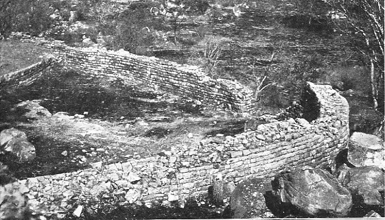
Khami is a ruined city located 22 kilometres (14 mi) west of Bulawayo, in Zimbabwe. It was once the capital of the Kingdom of Butua of the Torwa dynasty. It is now a national monument and became a UNESCO World Heritage Site in 1986.
Text: Wikipedia (CC BY-SA 4.0). Photo: David Randall-MacIver (Public domain). Map

Matobo National ParkUNESCO
Park & nature · Matabeleland South Province
The Matobo National Park forms the core of the Matobo or Matopos Hills, an area of granite kopjes and wooded valleys commencing some 35 kilometres (22 mi) south of Bulawayo, southern Zimbabwe.
Text: Wikipedia (CC BY-SA 4.0). Photo: Macvivo at English Wikipedia (Original text: Samwise Gamgee) (CC BY-SA 3.0). Map

Harare
City · Harare Province
Harare is the capital and largest city of Zimbabwe. The city proper has an area of 982.3 km2 (379.3 sq mi), a population of 1,849,600 as of the 2022 census, and an estimated 2,487,209 people in its metropolitan province.
Text: Wikipedia (CC BY-SA 4.0). Photo: Radozw at Serbian Wikipedia (CC BY-SA 3.0). Map
Bulawayo
City · Bulawayo Province
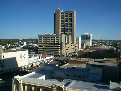
Bulawayo is the second largest city in Zimbabwe, and the largest city in the country's Matabeleland region. The city's population is disputed; the 2022 census listed it at 665,940, while the Bulawayo City Council claimed it to be about 1.2 million.
Text: Wikipedia (CC BY-SA 4.0). Photo: Prince Phumulani Nyoni (Public domain). Map

Hwange National Park
Park & nature
Hwange National Park, formerly Wankie Game Reserve is the largest protected area in Zimbabwe, with about 14,600 km2 (5,600 sq mi) in size. It was founded in 1928 and lies in the northwest of the country, between Bulawayo and Victoria Falls. The nearest town is Dete.
Text: Wikipedia (CC BY-SA 4.0). Photo: JackyR (CC BY-SA 3.0). Map

Mount Nyangani
Mountain · Manicaland Province
Mount Nyangani is the highest mountain in Zimbabwe at 2,592 metres or 8,504 feet. The mountain is located within Nyanga National Park in Nyanga District, about 110 km (68 mi) north-northeast of Mutare.
Text: Wikipedia (CC BY-SA 4.0). Photo: Babakathy at English Wikipedia (Public domain). Map

Mutarazi Falls
Waterfall · Manicaland Province
Mutarazi Falls is a waterfall in Mutasa District in Manicaland Province, Zimbabwe. It is located in the 2,495 hectare Mutarazi National Park adjacent to the southern border of the Nyanga National Park.
Text: Wikipedia (CC BY-SA 4.0). Photo: Bart Wursten (CC BY-SA 3.0). Map

Gonarezhou National Park
Park & nature · Masvingo Province
Gonarezhou National Park is a national park located in southeastern Zimbabwe. It is situated in a relatively remote corner of Masvingo Province, south of Chimanimani along the Mozambique border.
Text: Wikipedia (CC BY-SA 4.0). Photo: Ralf Ellerich (CC BY-SA 3.0). Map

Zambezi National Park
Park & nature · Matabeleland North Province
Zambezi National Park is a national park in Zimbabwe located upstream from Victoria Falls on the Zambezi River. It was split off from Victoria Falls National Park in 1979 and is 56,000 hectares in size.
Text: Wikipedia (CC BY-SA 4.0). Photo: Harvey Barrison from Massapequa, NY, USA (CC BY-SA 2.0). Map


Keep exploring
Also in Eastern Africa: Kenya · Tanzania · Ethiopia · British Indian Ocean Territory · Burundi · Comoros · Djibouti · Eritrea
Last updated November 12, 2026. Sources: Wikipedia (CC BY-SA 4.0), Wikimedia Commons, OpenStreetMap (ODbL). Partner offers below are separate from this guide and never change what’s written here.
Plan & book Zimbabwe
Partner linksVoyaKin may earn a commission if you book through a partner link. It doesn’t change your price. How we work with partners
Flights
Kiwi.com
Search flights on Kiwi.com
Compare routes to and from this country.
Partner link. VoyaKin may earn a commission if you book through this link, at no extra cost to you.
Tours & experiences
 3 hLivingstone Island Devils Pool 5.0 (51)From US$260 on Viator
 2 hVictoria Falls Guided Experience 5.0 (46)From US$30 on Viator
 2 hStandard Sunset Cruise 5.0 (46)From US$72 on Viator
 3 hOff the Beaten Path: Unique Safaris in Zambezi NP *GB-D-F-ES 5.0 (40)From US$125 on Viator
 9 hChobe Full Day Trip from Victoria Falls 5.0 (37)From US$169 on Viator
 6 hGuided Tour of Victoria Falls Zimbabwe and Zambia Experience 5.0 (28)From US$78 on Viator
 2 h–3 hGuided Tour of the Falls Rainforest 5.0 (28)From US$70 on Viator
 7 hLivingstone Victoria Falls Tour Zambia And Zimbabwe Combo 5.0 (27)From US$90 on Viator
 1.5 hRural Community Horse Rides – A Journey into Village Life 5.0 (23)From US$150 on Viator
 2 h–3 hVictoria Falls Guided Walking Tour with a Local Expert 5.0 (20)From US$40 on Viator
Partner links via Viator. Ratings, reviews and prices come from Viator and may change. VoyaKin may earn a commission if you book through a partner link. It doesn’t change your price.
eSIM & staying connected
Saily
Stay connected: get an eSIM before you fly.
VoyaKin travelers get US$5 off their first Saily plan with code VOYAKIN9122.
VoyaKin readers’ code
Partner link. VoyaKin may earn a commission if you book through this link, at no extra cost to you.
Partner linksVoyaKin may earn a commission if you book through a partner link. It doesn’t change your price. How we work with partners