Travel Hub
Plan a trip to Burundi

Burundi at a glance
Burundi is a country in Eastern Africa; its capital is Gitega. People mainly speak Rundi, French and English. The currency is the Burundian Franc (BIF). VoyaKin maps 18 places to see here.
- Flag
- 🇧🇮
- Capital
- Gitega
- Region
- Eastern Africa
- Languages
- Rundi, French, English
- Currency
- Burundian Franc (BIF)
- More
- Wikidata
Before you go: official information
Entry rules, visas and health requirements change. Confirm them with Burundi’s official immigration authority or its embassy before you book and again before you travel.
Check your own government’s travel advice before you go.
Places to see in Burundi
12 of the 18 places VoyaKin maps here. Descriptions from Wikipedia and photos from Wikimedia Commons, credited on each card.

Lake Tanganyika
Lac Tanganyika / Lake Tanganyika
Lake
Lake Tanganyika is an African Great Lake. It is the world's second-largest freshwater lake by volume and the second deepest, in both cases after Lake Baikal in Siberia. It is the world's longest freshwater lake. It is also the 6th largest lake by area.
Text: Wikipedia (CC BY-SA 4.0). Photo: Orrling (CC BY-SA 3.0). Map

Bujumbura
City · Bujumbura Mairie
Bujumbura, formerly Usumbura, is the economic capital, former political capital, largest city and main port of Burundi. It ships most of the country's chief export, coffee, as well as cotton and tin ore. Bujumbura was formerly the country's political capital.
Text: Wikipedia (CC BY-SA 4.0). Photo: Edouard mhg (CC BY-SA 4.0). Map

Gitega
City · Gitega Province
Gitega, formerly Kitega, is the political capital of Burundi.
Text: Wikipedia (CC BY-SA 4.0). Photo: Wikimedia Commons: Gitega.JPG (Public domain). Map

Ngozi
City · Ngozi
Ngozi is a town located in northern Burundi. It is the largest urban center in the Ngozi Province and the location of the provincial headquarters.
Text: Wikipedia (CC BY-SA 4.0). Photo: The original uploader was Acntx at English Wikipedia (CC BY-SA 3.0). Map

Muyinga
City · Muyinga
Muyinga is a city located in northern Burundi. It was the capital city of the former Muyinga Province. It lies at an altitude of 1,731 m and has a population of 100,715.
Text: Wikipedia (CC BY-SA 4.0). Photo: NIHEREWENIMANA Richard (CC BY-SA 4.0). Map

Lake Rweru
Lake · Kirundo
Lake Rweru is a lake close to the northernmost point of Burundi in central Africa. The northern shore of the lake forms part of Burundi's border with Rwanda. It is the most distant origin point of the Nile River.
Text: Wikipedia (CC BY-SA 4.0). Photo: NASA (Public domain). Map

Mount Heha
umusozi Heha
Mountain · Bujumbura Rural Province
Mount Heha is the highest mountain in Burundi and the highest point in the Burundi Highlands mountain range.
Text: Wikipedia (CC BY-SA 4.0). Photo: Wikimedia Commons: Mont Heha Cropped.jpg (CC BY-SA 4.0). Map

Kibira National Park
Parc national de la Kibira
Park & nature · Bubanza
The Kibira National Park is a national park in northwestern Burundi. Overlapping four provinces and covering 400 km2 (150 sq mi), Kibira National Park lies atop the mountains of the Congo-Nile Divide.
Text: Wikipedia (CC BY-SA 4.0). Photo: NZISABIRA Léopold (CC BY-SA 4.0). Map

Ruvubu National Park
Parc national de la Ruvubu
Park & nature · Cankuzo
Ruvubu National Park is a national park in Burundi covering 508 km2 (196 mi2) that was established in 1980. Its borders fall within the provinces of Karuzi, Muyinga, Cankuzo and Ruyigi.
Text: Wikipedia (CC BY-SA 4.0). Photo: IRAKOZE Juliette (CC BY-SA 4.0). Map
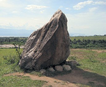
Livingstone–Stanley Monument
Memorial · Bujumbura Rural Province
The Livingstone–Stanley Monument at Mugere marks a location where explorer and missionary Dr David Livingstone and journalist and explorer Henry Morton Stanley visited and spent two nights on 25–27 November 1871 in Burundi.
Text: Wikipedia (CC BY-SA 4.0). Photo: Wikimedia Commons: Livingstone monument burundi.jpg (Public domain). Map

Karera waterfalls
Chutes de la Kagera
Waterfall · Burunga
The Chutes de la Karera are a spectacular series of waterfalls in southeastern Burundi. They are located to the south of Rutana. The falls occupy over 142 hectares, being made up of six branches divided on three landings.
Text: Wikipedia (CC BY-SA 4.0). Photo: Zamennest (CC BY-SA 4.0). Map


Keep exploring
Also in Eastern Africa: Kenya · Tanzania · Ethiopia · British Indian Ocean Territory · Comoros · Djibouti · Eritrea · French Southern and Antarctic Lands
Last updated November 12, 2026. Sources: Wikipedia (CC BY-SA 4.0), Wikimedia Commons, OpenStreetMap (ODbL). Partner offers below are separate from this guide and never change what’s written here.
Plan & book Burundi
Partner linksVoyaKin may earn a commission if you book through a partner link. It doesn’t change your price. How we work with partners
Flights
Kiwi.com
Search flights on Kiwi.com
Compare routes to and from this country.
Partner link. VoyaKin may earn a commission if you book through this link, at no extra cost to you.
Tours & experiences
 72 h3 Day Burundi Tour- Multi-Day Burundi Sightseeing Tour with Karera Waterfalls 5.0 (7)From US$1,116 on Viator
 72 h3 Day Burundi Nile Source Gitega Rusizi Park 5.0 (5)From US$1,500 on Viator
 168 hDiscovering the Wonders of Burundi: A 7-Day Tour itinerary 5.0 (2)From US$2,292 on Viator
 5 hPrivate Tour of Bujumbura 5.0 (2)From US$435 on Viator
 9 hDay Trip to Gitega Royal Drummers- Songa Mount Hiking – Architecture Tour 5.0 (1)From US$392 on Viator
 9 hFull-Day Tour Bujumbura With Rusizi Park And Stanley Monument 5.0 (1)From US$300 on Viator
 8 hMuramvya: Kibira National Park – Tea plantations 5.0 (1)From US$380 on Viator
 9 hBurundi Day Trip to Karera Waterfalls- Source of Nile-Gitega National Museum 5.0 (1)From US$450 on Viator
 8 hFrom Bujumbura: Private Day Tour-Gitega-Gishora Drum Sanctuary 4.5 (4)From US$285 on Viator
 8 hBujumbura City Tour 4.5 (4)From US$323 on Viator
Partner links via Viator. Ratings, reviews and prices come from Viator and may change. VoyaKin may earn a commission if you book through a partner link. It doesn’t change your price.
eSIM & staying connected
Saily
Stay connected: get an eSIM before you fly.
VoyaKin travelers get US$5 off their first Saily plan with code VOYAKIN9122.
VoyaKin readers’ code
Partner link. VoyaKin may earn a commission if you book through this link, at no extra cost to you.
Partner linksVoyaKin may earn a commission if you book through a partner link. It doesn’t change your price. How we work with partners