Travel Hub
Plan a trip to Eritrea

Eritrea at a glance
Eritrea is a country in Eastern Africa; its capital is Asmara. People mainly speak Tigrinya, English and Arabic. The currency is the Eritrean Nakfa (ERN). VoyaKin maps 17 places to see here, including 2 UNESCO World Heritage sites.
- Flag
- 🇪🇷
- Capital
- Asmara
- Region
- Eastern Africa
- Languages
- Tigrinya, English, Arabic
- Currency
- Eritrean Nakfa (ERN)
- More
- Wikidata
Before you go: official information
Entry rules, visas and health requirements change. Confirm them with Eritrea’s official immigration authority or its embassy before you book and again before you travel.
Check your own government’s travel advice before you go.
Places to see in Eritrea
12 of the 17 places VoyaKin maps here. Descriptions from Wikipedia and photos from Wikimedia Commons, credited on each card.


Asmara
City · Maekel Region
Asmara, or Asmera, is the capital and most populous city of Eritrea, in the country's Central Region. It sits at an elevation of 2,325 metres (7,628 ft), making it the sixth-highest capital in the world by altitude and the second-highest capital in Africa.
Text: Wikipedia (CC BY-SA 4.0). Photo: sailko (CC BY-SA 3.0). Map

Massawa
City · Northern Red Sea Region
Massawa or Mitsiwa is a port city in the Northern Red Sea region of Eritrea, located on the Red Sea at the northern end of the Gulf of Zula beside the Dahlak Archipelago. It has been a historically important port for many centuries.
Text: Wikipedia (CC BY-SA 4.0). Photo: Reinhard Dietrich (CC0). Map

Keren
City · Anseba Region
Keren, historically known as Sanhit, is the second-largest city in Eritrea. It is situated around 91 kilometres (57 mi) northwest of Asmara at an elevation of 1,590 metres (5,220 ft) above sea-level. The city sprawls on a wide basin surrounded by granitic mountains on all sides.
Text: Wikipedia (CC BY-SA 4.0). Photo: Mheidegger (CC BY 4.0). Map

Mendefera
City · Debub Region
Mendefera, formerly Adi Ugri, is an ancient town which is now the capital city of the Southern Region or Zoba Debub of Eritrea.
Text: Wikipedia (CC BY-SA 4.0). Photo: David Stanley from Nanaimo, Canada (CC BY 2.0). Map

Mosque of the Companions
Masjid Sahaba
Religious · Northern Red Sea Region
The Mosque of the Companions, also known as the Ras Medre Mosque, is an open-air mosque in Massawa, Eritrea, located on a small island off the Red Sea coast. According to local tradition, the mosque dates from the early 7th century CE and is believed by some to be the first mosque in Africa.
Text: Wikipedia (CC BY-SA 4.0). Photo: Mheidegger (CC BY 4.0). Map
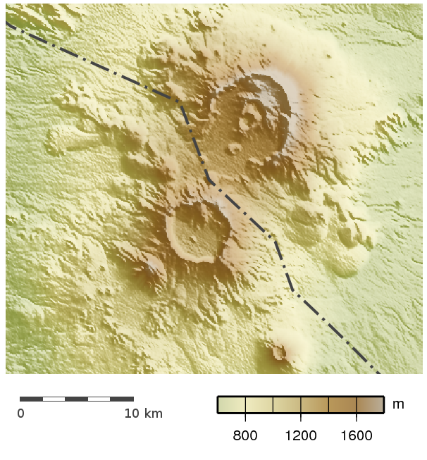
Nabro Volcano
Mountain · Southern Red Sea Region
The Nabro Volcano is an active stratovolcano in the Southern Red Sea Region of Eritrea. It is located at the south-east end of the Danakil Alps in the Danakil Depression. Before its 2011 eruption, the volcano was widely believed to be extinct.
Text: Wikipedia (CC BY-SA 4.0). Photo: Carport (CC BY-SA 3.0). Map

Dahlak Kebir
Island · Northern Red Sea Region
Dahlak Kebir is the largest island of the Dahlak Archipelago. Situated in the Red Sea off of the coast of Eritrea, it was formerly called Dahlak Deset.
Text: Wikipedia (CC BY-SA 4.0). Photo: Amod Photography (CC BY-SA 4.0). Map

Harmil
Island · Northern Red Sea Region
Harmil is an uninhabited island in Eritrea that forms part of the Dahlak Archipelago. The inhabitants are serving members of the Eritrean Navy who have a small outpost on the island.
Text: Wikipedia (CC BY-SA 4.0). Photo: user:Hautala (Public domain). Map

Nora
Island · Northern Red Sea Region
Nora is the second largest island in the Dahlak Archipelago, Eritrea, and one of the three inhabited islands of the archipelago. It has an area of 105.15 km2 (40.60 sq mi). It reaches a maximum height of 37 meters in the northeast.
Text: Wikipedia (CC BY-SA 4.0). Photo: NASA World Wind (Public domain). Map

Debre Bizen
Religious · Northern Red Sea Region
Debre Bizen is an Eritrean Orthodox Tewahedo Church monastery. Located at the top of Debre Bizen the mountain near the town of Nefasit in Eritrea. Its library contains many important Ge'ez manuscripts.
Text: Wikipedia (CC BY-SA 4.0). Photo: Grullab (CC BY-SA 4.0). Map


Keep exploring
Also in Eastern Africa: Kenya · Tanzania · Ethiopia · British Indian Ocean Territory · Burundi · Comoros · Djibouti · French Southern and Antarctic Lands
Last updated November 12, 2026. Sources: Wikipedia (CC BY-SA 4.0), Wikimedia Commons, OpenStreetMap (ODbL). Partner offers below are separate from this guide and never change what’s written here.
Plan & book Eritrea
Partner linksVoyaKin may earn a commission if you book through a partner link. It doesn’t change your price. How we work with partners
Flights
Kiwi.com
Search flights on Kiwi.com
Compare routes to and from this country.
Partner link. VoyaKin may earn a commission if you book through this link, at no extra cost to you.
Tours & experiences
 96 h4 Days Private Eritrea Tour with Transfer 5.0 (10)From US$1,400 on Viator
 96 h4 days tour Asmara - Keren - Massawa 4.9 (18)From US$1,400 on Viator
 4 h–8 hAsmara City Tour 4.9 (32)From US$149 on Viator
 72 h3 days tour Asmara - Massawa - Keren 4.8 (14)From US$1,144 on Viator
 168 h7 Days Private Eritrea Tour 5.0 (6)From US$2,000 on Viator
 192 h8 Days in Eritrea Asmara Ancient Sites and Red Sea Paradise 5.0 (6)From US$2,150 on Viator
 216 h9-Day Private Eritrea Tour: Asmara, Keren, Massawa and Adulis 5.0 (2)From US$2,300 on Viator
Partner links via Viator. Ratings, reviews and prices come from Viator and may change. VoyaKin may earn a commission if you book through a partner link. It doesn’t change your price.
eSIM & staying connected
Saily
Stay connected: get an eSIM before you fly.
VoyaKin travelers get US$5 off their first Saily plan with code VOYAKIN9122.
VoyaKin readers’ code
Partner link. VoyaKin may earn a commission if you book through this link, at no extra cost to you.
Partner linksVoyaKin may earn a commission if you book through a partner link. It doesn’t change your price. How we work with partners