Travel Hub
Plan a trip to Zambia

Zambia at a glance
Zambia is a country in Eastern Africa; its capital is Lusaka. People mainly speak English. The currency is the Zambian Kwacha (ZMW). VoyaKin maps 20 places to see here, including 1 UNESCO World Heritage site.
- Flag
- 🇿🇲
- Capital
- Lusaka
- Region
- Eastern Africa
- Languages
- English
- Currency
- Zambian Kwacha (ZMW)
- More
- Wikidata
Before you go: official information
Entry rules, visas and health requirements change. Confirm them with Zambia’s official immigration authority or its embassy before you book and again before you travel.
Check your own government’s travel advice before you go.
Places to see in Zambia
12 of the 20 places VoyaKin maps here. Descriptions from Wikipedia and photos from Wikimedia Commons, credited on each card.

Lusaka
City · Lusaka Province
Lusaka is the capital and largest city of Zambia. It is one of the fastest-developing cities in southern Africa. Lusaka is in the southern part of the central plateau at an elevation of about 1,279 metres (4,196 ft). As of 2022, the city's population was approximately 2,204,059.
Text: Wikipedia (CC BY-SA 4.0). Photo: Matthew Grollnek (CC BY-SA 4.0). Map

Ndola
City · Copperbelt Province
Ndola is the third largest city in Zambia in terms of size and population, with a population of 624,579 ,. after the capital, Lusaka, and Kitwe, and the second largest in terms of infrastructure development after Lusaka.
Text: Wikipedia (CC BY-SA 4.0). Photo: Vberger (Public domain). Map

Livingstone
City · Southern Province
Livingstone is a city in Southern Province, Zambia. Lying 10 km (6 mi) to the north of the Zambezi River, it is a tourist attraction due to its proximity to the Victoria Falls and its road and rail connections to Victoria Falls, Zimbabwe, the resort town on the opposite side of the falls.
Text: Wikipedia (CC BY-SA 4.0). Photo: cowbridgeguide.co.uk (CC BY 3.0). Map

Kitwe
City · Copperbelt Province
Kitwe is the third largest city in terms of infrastructure development and second largest city in terms of size and population in Zambia. With a population of 661,901 as of the 2022 census, Kitwe is one of the most developed commercial and industrial areas in the nation, alongside Ndola and Lusaka.
Text: Wikipedia (CC BY-SA 4.0). Photo: Mike Rosenberg from London, England (CC BY 2.0). Map

Lake Bangweulu
Lake · Luapula Province
Lake Bangweulu is a freshwater lake in northern Zambia.
Text: Wikipedia (CC BY-SA 4.0). Photo: Rexparry_sydney (CC BY 2.5). Map
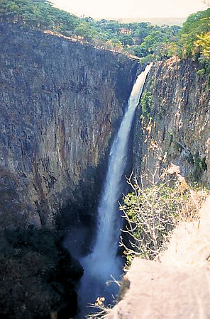
Kalambo Falls
Waterfall · Northern Province
The Kalambo Falls on the Kalambo River is a 235-metre (772 ft) single-drop waterfall on the border of Zambia and Rukwa Region, Tanzania at the southeast end of Lake Tanganyika. The falls are some of the tallest uninterrupted falls in Africa.
Text: Wikipedia (CC BY-SA 4.0). Photo: Worldtraveller at English Wikipedia (CC BY-SA 3.0). Map

South Luangwa National Park
Park & nature · Eastern Province
South Luangwa National Park is a national park in eastern Zambia that was founded as a game reserve in 1938 and became a national park in 1972. It covers 9,050 km2 (3,490 sq mi) in the valley of the Luangwa River, which forms its eastern boundary in the Eastern Province of Zambia.
Text: Wikipedia (CC BY-SA 4.0). Photo: Geoff Gallice (CC BY 2.0). Map

Victoria Falls Bridge
Viewpoint · Southern Province
The Victoria Falls Bridge crosses the Zambezi River just below the Victoria Falls and is built over the Second Gorge of the falls.
Text: Wikipedia (CC BY-SA 4.0). Photo: Wikimedia Commons: Victoria Falls Bridge.JPG (Public domain). Map

Kafue National Park
Park & nature · Central Province
Kafue National Park is the largest national park in Zambia, covering an area of about 22,400 km2 (8,600 sq mi). It is the second largest national park in Africa and home to 152 mammal species. There are also 515 bird species, 70 reptile species, 58 species of fish and 36 amphibious species.
Text: Wikipedia (CC BY-SA 4.0). Photo: LittleT889 (CC BY-SA 4.0). Map
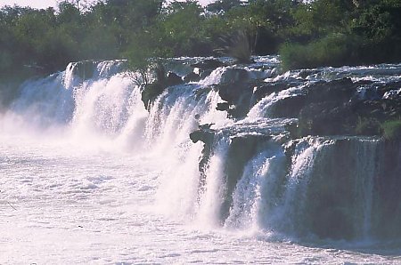
Ngonye Falls
Waterfall · Western Province
The Ngonye Falls or Sioma Falls is a waterfall on the Zambezi river in Western province Zambia, near the town of Sioma and a few hundred kilometres upstream from the Victoria Falls. Situated in the southern part of Barotseland, the falls are a day's journey by car from the capital, Lusaka.
Text: Wikipedia (CC BY-SA 4.0). Photo: Wikimedia Commons: Ngonye Falls.jpg (CC BY-SA 3.0). Map

Lower Zambezi National Park
Park & nature · Lusaka Province
The Lower Zambezi National Park lies on the north bank of the Zambezi River in southeastern Zambia. Until 1983 when the area was declared a national park, the area was the private game reserve of Zambia's president.
Text: Wikipedia (CC BY-SA 4.0). Photo: Joachim Huber from Switzerland (CC BY-SA 2.0). Map


Keep exploring
Also in Eastern Africa: Kenya · Tanzania · Ethiopia · British Indian Ocean Territory · Burundi · Comoros · Djibouti · Eritrea
Last updated November 12, 2026. Sources: Wikipedia (CC BY-SA 4.0), Wikimedia Commons, OpenStreetMap (ODbL). Partner offers below are separate from this guide and never change what’s written here.
Plan & book Zambia
Partner linksVoyaKin may earn a commission if you book through a partner link. It doesn’t change your price. How we work with partners
Flights
Kiwi.com
Search flights on Kiwi.com
Compare routes to and from this country.
Partner link. VoyaKin may earn a commission if you book through this link, at no extra cost to you.
Tours & experiences
 5 hZambezi River Class 5- Whitewater Rafting- Half Day with Lunch 5.0 (40)From US$140 on Viator
 15 min–30 minLivingstone Airport Transfers (LVI) – Reliable Pickup or Drop off 5.0 (40)From US$15 on Viator
 3.5 hRhino Walking Safari Experience- MINIMUM 2 PEOPLE 5.0 (38)From US$95 on Viator
 4 hHalf Day Zambezi River White Water Rafting 5.0 (29)From US$130 on Viator
 5 hLivingstone: Swim Below Victoria Falls and Zambezi Rafting Combo 5.0 (26)From US$220 on Viator
 3 hGame drive and short rhino walk 5.0 (17)From US$70 on Viator
 48 hChobe Full day Safari: Game Drive & Boat Safari with Lunch 5.0 (16)From US$280 on Viator
 2 hLivingstone Mukuni Village Tour 5.0 (12)From US$30 on Viator
 3 hRhino Walking Safari 5.0 (11)From US$140 on Viator
 2 h–3 hGuided Tour of the Falls Zambia 5.0 (10)From US$60 on Viator
Partner links via Viator. Ratings, reviews and prices come from Viator and may change. VoyaKin may earn a commission if you book through a partner link. It doesn’t change your price.
eSIM & staying connected
Saily
Stay connected: get an eSIM before you fly.
VoyaKin travelers get US$5 off their first Saily plan with code VOYAKIN9122.
VoyaKin readers’ code
Partner link. VoyaKin may earn a commission if you book through this link, at no extra cost to you.
Partner linksVoyaKin may earn a commission if you book through a partner link. It doesn’t change your price. How we work with partners