Travel Hub
Plan a trip to St. Vincent & Grenadines
St. Vincent & Grenadines at a glance
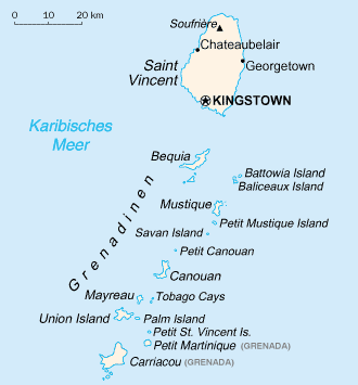
St. Vincent & Grenadines is a country in Caribbean; its capital is Kingstown. People mainly speak English. The currency is the East Caribbean Dollar (XCD). VoyaKin maps 12 places to see here.
- Flag
- 🇻🇨
- Capital
- Kingstown
- Region
- Caribbean
- Languages
- English
- Currency
- East Caribbean Dollar (XCD)
- More
- Wikidata
Before you go: official information
Entry rules, visas and health requirements change. Confirm them with St. Vincent & Grenadines’s official immigration authority or its embassy before you book and again before you travel.
Check your own government’s travel advice before you go.
Places to see in St. Vincent & Grenadines
Descriptions from Wikipedia and photos from Wikimedia Commons, credited on each card.

Kingstown
Town · Saint George Parish
Kingstown is the capital and largest city of Saint Vincent and the Grenadines. The city, located on the main island of Saint Vincent, has the main port and the biggest commercial center of the islands. With a population of 12,909 (2012), Kingstown is the most populous settlement in the country.
Text: Wikipedia (CC BY-SA 4.0). Photo: giggel (CC BY 3.0). Map

Saint Vincent
Island · Saint Patrick
Saint Vincent is a volcanic island in the southern Caribbean. It is the largest island of the country Saint Vincent and the Grenadines and is located in the Caribbean Sea, between Saint Lucia and Grenada. It is composed of partially submerged volcanic mountains.
Text: Wikipedia (CC BY-SA 4.0). Photo: David Stanley from Nanaimo, Canada (CC BY 2.0). Map
Mustique
Island · Grenadines Parish
Mustique is a 2,470 hectares private island in Saint Vincent and the Grenadines. It is part of the Grenadines, a chain of islands in the West Indies. The island is located within Grenadines Parish, and the closest island is the uninhabited Petite Mustique, located 2 km (1.2 mi) to the south.
Text: Wikipedia (CC BY-SA 4.0). Photo: United States Central Intelligence Agency (Public domain). Map

Bequia
Island · Grenadines Parish
Bequia is the second-largest island in the Grenadines at 7 square miles (18 km2). It is part of the country of Saint Vincent and the Grenadines and lies approximately 15 kilometres (9.3 mi) from the nation's capital, Kingstown, on the main island, Saint Vincent.
Text: Wikipedia (CC BY-SA 4.0). Photo: David Stanley from Nanaimo, Canada (CC BY 2.0). Map

La Soufrière
Soufriere Volcano Peak
Mountain · Charlotte Parish
La Soufrière or Soufrière Saint Vincent is an active volcano on the Caribbean island of Saint Vincent in Saint Vincent and the Grenadines. It is the highest peak on Saint Vincent, and has had eight recorded eruptions since 1718.
Text: Wikipedia (CC BY-SA 4.0). Photo: Wikimedia Commons: Soufriere.jpg (CC BY-SA 3.0). Map

Canouan
Island · Grenadines Parish
Canouan is an island in the Grenadines. It is a small island, measuring only 5.6 by 2 km, and has a surface of 7.6 km2. It lies approximately 40 km (25 mi) south of the island of St. Vincent. The population is about 1,700. The largest settlement on the island is Charlestown.
Text: Wikipedia (CC BY-SA 4.0). Photo: Jason Pratt from Pittsburgh, PA (CC BY 2.0). Map

Georgetown
Town · Charlotte Parish
Georgetown is a town located on the island of Saint Vincent. It is the largest city in Charlotte Parish. Georgetown was one of the main sites for sugar production in the island.
Text: Wikipedia (CC BY-SA 4.0). Photo: Diego Tirira from Quito, Ecuador (CC BY-SA 2.0). Map

Port Elizabeth
Town · Grenadines Parish
Port Elizabeth is a town located on the island of Bequia, which is part of the Grenadines island chain. It is the capital of Grenadines Parish. The town was named after Princess Elizabeth in 1937 to commemorate the coronation of her parents.
Text: Wikipedia (CC BY-SA 4.0). Photo: Joyce Hill, uploaded by en:User:John Hill (CC BY-SA 3.0). Map

Barrouallie
Town · Saint Patrick Parish
Barrouallie is a town located on the island of Saint Vincent. Barrouallie was established by French settlers in 1719, the first European colony on St. Vincent. Once it was the capital of St.Vincent and the Grenadines.
Text: Wikipedia (CC BY-SA 4.0). Photo: Tempest Anderson (Public domain). Map


Fort Charlotte
Fort · Saint George Parish
Fort Charlotte is a British-colonial era fort, built on a hill overlooking the harbour of Kingstown, Saint Vincent. It is located in the parish of Saint Andrew, Saint Vincent and the Grenadines at the top of Edinboro road, on Berkshire Hill, just west of the town.
Text: Wikipedia (CC BY-SA 4.0). Photo: giggel (CC BY 3.0). Map


Keep exploring
Also in Caribbean: Jamaica · Dominican Republic · Barbados · Bahamas · Anguilla · Antigua & Barbuda · Aruba · British Virgin Islands
Last updated November 12, 2026. Sources: Wikipedia (CC BY-SA 4.0), Wikimedia Commons, OpenStreetMap (ODbL). Partner offers below are separate from this guide and never change what’s written here.
Plan & book St. Vincent & Grenadines
Partner linksVoyaKin may earn a commission if you book through a partner link. It doesn’t change your price. How we work with partners
Flights
Kiwi.com
Search flights on Kiwi.com
Compare routes to and from this country.
Partner link. VoyaKin may earn a commission if you book through this link, at no extra cost to you.
eSIM & staying connected
Saily
Stay connected: get an eSIM before you fly.
VoyaKin travelers get US$5 off their first Saily plan with code VOYAKIN9122.
VoyaKin readers’ code
Partner link. VoyaKin may earn a commission if you book through this link, at no extra cost to you.
Partner linksVoyaKin may earn a commission if you book through a partner link. It doesn’t change your price. How we work with partners