Travel Hub
Plan a trip to Anguilla

Anguilla at a glance
Anguilla is a territory in Caribbean; its capital is The Valley. People mainly speak English. The currency is the East Caribbean Dollar (XCD). VoyaKin maps 8 places to see here.
- Flag
- 🇦🇮
- Capital
- The Valley
- Region
- Caribbean
- Languages
- English
- Currency
- East Caribbean Dollar (XCD)
- More
- Wikidata
Before you go: official information
Entry rules, visas and health requirements change. Confirm them with Anguilla’s official immigration authority or its embassy before you book and again before you travel.
Check your own government’s travel advice before you go.
Places to see in Anguilla
Descriptions from Wikipedia and photos from Wikimedia Commons, credited on each card.

The Valley
Town
The Valley is the capital of Anguilla, one of its fourteen districts, and the main town on the island. As of 2011, it had a population of 3,269.
Text: Wikipedia (CC BY-SA 4.0). Photo: Josveek Huligar (permission given in e-mail) (CC BY-SA 3.0). Map

Sombrero
Island
Sombrero, also known as Hat Island, is part of the British Overseas Territory of Anguilla and is the northernmost island of the Lesser Antilles. It lies 54 km (34 mi) north-west of Anguilla across the Dog and Prickly Pear Passage.
Text: Wikipedia (CC BY-SA 4.0). Photo: Wikimedia Commons: Sombrero map.jpg (Public domain). Map

Dog Island
Island
Dog Island is an uninhabited small island of 207 ha located approximately 13 km (8.1 mi) to the north-west of Anguilla, a British Overseas Territory in the Caribbean. It is low and rocky, with three small cays off the west and north coasts.
Text: Wikipedia (CC BY-SA 4.0). Photo: Wikimedia Commons: Anguilla-CIA WFB Map.png (Public domain). Map

Scrub Island
Island
Scrub Island is an 8 km2 (3.1 sq mi) island lying off the eastern tip of the main island of Anguilla, a British Overseas Territory in the Caribbean. The island has been identified as an Important Bird Area by BirdLife International due to its importance as a breeding site for seabirds.
Text: Wikipedia (CC BY-SA 4.0). Photo: The original uploader was Lythium at English Wikipedia (CC BY-SA 3.0). Map
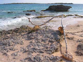
Anguillita
Island
Anguillita is a small, uninhabited rocky island off the western tip of, and part of the territory of Anguilla, located in the Caribbean. It is the dependency's southernmost point.
Text: Wikipedia (CC BY-SA 4.0). Photo: AnguillaGirl (CC BY 3.0). Map
Ronald Webster Park
Park & nature
Ronald Webster Park is a sports venue in The Valley, Anguilla. It is currently used mostly for football matches, although most years the Leeward Islands cricket team play one of their matches in the Regional Four Day Competition on this ground, as well as local athletics clubs.


Keep exploring
Also in Caribbean: Jamaica · Dominican Republic · Barbados · Bahamas · Antigua & Barbuda · Aruba · British Virgin Islands · Caribbean Netherlands
Last updated November 12, 2026. Sources: Wikipedia (CC BY-SA 4.0), Wikimedia Commons, OpenStreetMap (ODbL). Partner offers below are separate from this guide and never change what’s written here.
Plan & book Anguilla
Partner linksVoyaKin may earn a commission if you book through a partner link. It doesn’t change your price. How we work with partners
Flights
Kiwi.com
Search flights on Kiwi.com
Compare routes to and from this country.
Partner link. VoyaKin may earn a commission if you book through this link, at no extra cost to you.
Tours & experiences
 3.5 hAnguilla Based:Scheduled 2-Tank Dive (Certified Divers) 5.0 (19)From US$250 on Viator
 2 hAnguilla Based: 2-Hr Group Snorkel at Little Bay Marine Park. 4.9 (19)From US$100 on Viator
 1 hNight Kayaking in Clear Kayaks | Glowing Waters & Stars 4.8 (48)From US$110 on Viator
 2 hMorning Clear Kayak Tour to Little Bay + Snorkeling 4.5 (13)From US$123 on Viator
 2 hAnguilla Based: PADI Discover Scuba (Introductory Dive) 5.0 (5)From US$250 on Viator
 2 hAnguilla Based: 1-Tank Group Night Dive (certification Required) 5.0 (2)From US$300 on Viator
 3 hAnguilla Based: Private 3-Hr Sightseeing & Snorkel Charter 5.0 (2)From US$825 on Viator
 1 hCultural Salt Picking Experience in Anguilla 5.0 (1)From US$85 on Viator
 4 hAnguilla Based:Complete your PADI Open Water Dives 3 & 4 with us 5.0 (1)From US$500 on Viator
 4 hAnguilla Based: 4-hr Private Snorkel & Sightseeing Charter 4.5 (6)From US$1,100 on Viator
Partner links via Viator. Ratings, reviews and prices come from Viator and may change. VoyaKin may earn a commission if you book through a partner link. It doesn’t change your price.
eSIM & staying connected
Saily
Stay connected: get an eSIM before you fly.
VoyaKin travelers get US$5 off their first Saily plan with code VOYAKIN9122.
VoyaKin readers’ code
Partner link. VoyaKin may earn a commission if you book through this link, at no extra cost to you.
Partner linksVoyaKin may earn a commission if you book through a partner link. It doesn’t change your price. How we work with partners