Travel Hub
Plan a trip to St. Kitts & Nevis

St. Kitts & Nevis at a glance
St. Kitts & Nevis is a country in Caribbean; its capital is Basseterre. People mainly speak English. The currency is the East Caribbean Dollar (XCD). VoyaKin maps 20 places to see here, including 1 UNESCO World Heritage site.
- Flag
- 🇰🇳
- Capital
- Basseterre
- Region
- Caribbean
- Languages
- English
- Currency
- East Caribbean Dollar (XCD)
- More
- Wikidata
Before you go: official information
Entry rules, visas and health requirements change. Confirm them with St. Kitts & Nevis’s official immigration authority or its embassy before you book and again before you travel.
Check your own government’s travel advice before you go.
Places to see in St. Kitts & Nevis
12 of the 20 places VoyaKin maps here. Descriptions from Wikipedia and photos from Wikimedia Commons, credited on each card.

Brimstone Hill Fortress National ParkUNESCO
Mountain · Saint Thomas Middle Island Parish
Brimstone Hill Fortress National Park is a UNESCO World Heritage Site, a well-preserved fortress on a hill on the island of St. Kitts, in the Federation of St. Christopher and Nevis in the Eastern Caribbean.
Text: Wikipedia (CC BY-SA 4.0). Photo: giggel (CC BY 3.0). Map

Basseterre
Town · Saint George Basseterre Parish
Basseterre is the capital and largest city of Saint Kitts and Nevis with an estimated population of 14,000 in 2018.
Text: Wikipedia (CC BY-SA 4.0). Photo: J. Stephen Conn (CC BY-SA 1.0). Map

Charlestown
City · Saint Paul Charlestown Parish
Charlestown is the capital of the island of Nevis in the Federation of Saint Kitts and Nevis in the Leeward Islands of the West Indies. Charlestown is situated on the leeward side of the island of Nevis near the southern end of Pinney's Beach.
Text: Wikipedia (CC BY-SA 4.0). Photo: Aaron Vos (CC BY-SA 2.5). Map

Mount Liamuiga
Mountain · Saint Kitts
Mount Liamuiga is a 1,156-metre (3,792 ft) stratovolcano which forms the north-western part of the island of Saint Kitts.
Text: Wikipedia (CC BY-SA 4.0). Photo: Wikimedia Commons: ISS022-E-39042 - View of the Lesser Antilles.jpg (Public domain). Map

Nevis Peak
Mountain
Nevis Peak is a potentially active volcano which is located in the centre of the island of Nevis of the Federation of Saint Kitts and Nevis in the West Indies. The stratovolcano rises to a height of 985 metres (3,232 ft) and is the highest point on the island.
Text: Wikipedia (CC BY-SA 4.0). Photo: Jensonmorton at English Wikipedia (Public domain). Map

Sandy Point Town
Town · Saint Anne Sandy Point Parish
Sandy Point is the second-largest town on the island of Saint Kitts, Saint Kitts and Nevis. The settlement is situated on the north-west coast of St. Kitts and is the capital of Saint Anne Sandy Point Parish. As of 2011, it had a population of 2,626.
Text: Wikipedia (CC BY-SA 4.0). Photo: Jensonmorton at English Wikipedia (Public domain). Map

Cayon
Town · Saint Mary Cayon Parish
Cayon is a town on the northeast coast of Saint Kitts in the Caribbean. It is the capital of Saint Mary Cayon Parish. The estimated population in 2010 was 2,500.
Text: Wikipedia (CC BY-SA 4.0). Photo: WindsorUniv (CC BY-SA 3.0). Map

Booby Island
Island · Saint George Basseterre Parish
Booby Island is an uninhabited islet in Saint Kitts and Nevis. It is found in the Narrows, the channel between the islands of Saint Kitts and Nevis, about midway between the two. Booby Island is cone-shaped, consisting of a steep hill and a rocky shoreline.
Text: Wikipedia (CC BY-SA 4.0). Photo: Sailing On Finding Avalon (CC BY 3.0). Map

Frigate Bay
Beach · Saint George Basseterre Parish
Frigate Bay is the name of two bays located close together on the island of Saint Kitts. The two bays are located southeast of the capital Basseterre, at the northern end of the isthmus joining the Southeast Peninsula with the rest of the island.
Text: Wikipedia (CC BY-SA 4.0). Photo: Dr. Thomas Liptak (CC BY-SA 4.0). Map

The Narrows
Lake
The Narrows is the strait that separates the Caribbean islands of Saint Kitts and Nevis. A Sea Bridge ferry traverses the Narrows regularly between Cades Bay, Nevis and Majors Bay at the southern end of St Kitts' Southeast Peninsula several times each day.
Text: Wikipedia (CC BY-SA 4.0). Photo: SV Zanshin (CC BY-SA 3.0). Map

Pinney's Beach
Beach · Saint Thomas Lowland Parish
Pinney's Beach, also spelled Pinneys Beach, is a very long sandy beach on the western Caribbean coast of the island of Nevis, in Saint Kitts and Nevis, Leeward Islands in the West Indies. The southern end of Pinneys Beach starts just outside the capital, Charlestown.
Text: Wikipedia (CC BY-SA 4.0). Photo: Dr. Thomas Liptak (CC BY-SA 4.0). Map
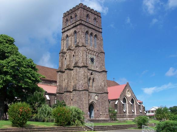
St. George's Anglican Church
Religious · Saint George Basseterre Parish
St. George's Anglican Church is an Anglican parish church and Pro-Cathedral in Basseterre, Saint Kitts and Nevis.
Text: Wikipedia (CC BY-SA 4.0). Photo: J. Stephen Conn (CC BY-SA 1.0). Map


Keep exploring
Also in Caribbean: Jamaica · Dominican Republic · Barbados · Bahamas · Anguilla · Antigua & Barbuda · Aruba · British Virgin Islands
Last updated November 12, 2026. Sources: Wikipedia (CC BY-SA 4.0), Wikimedia Commons, OpenStreetMap (ODbL). Partner offers below are separate from this guide and never change what’s written here.
Plan & book St. Kitts & Nevis
Partner linksVoyaKin may earn a commission if you book through a partner link. It doesn’t change your price. How we work with partners
Flights
Kiwi.com
Search flights on Kiwi.com
Compare routes to and from this country.
Partner link. VoyaKin may earn a commission if you book through this link, at no extra cost to you.
eSIM & staying connected
Saily
Stay connected: get an eSIM before you fly.
VoyaKin travelers get US$5 off their first Saily plan with code VOYAKIN9122.
VoyaKin readers’ code
Partner link. VoyaKin may earn a commission if you book through this link, at no extra cost to you.
Partner linksVoyaKin may earn a commission if you book through a partner link. It doesn’t change your price. How we work with partners