Travel Hub
Plan a trip to Cuba

Cuba at a glance
Cuba is a country in Caribbean; its capital is Havana. People mainly speak Spanish. The currency is the Cuban Peso (CUP). VoyaKin maps 20 places to see here, including 8 UNESCO World Heritage sites.
- Flag
- 🇨🇺
- Capital
- Havana
- Region
- Caribbean
- Languages
- Spanish
- Currency
- Cuban Peso (CUP)
- More
- Wikidata
Before you go: official information
Entry rules, visas and health requirements change. Confirm them with Cuba’s official immigration authority or its embassy before you book and again before you travel.
Check your own government’s travel advice before you go.
Places to see in Cuba
12 of the 20 places VoyaKin maps here. Descriptions from Wikipedia and photos from Wikimedia Commons, credited on each card.

Viñales ValleyUNESCO
Valle de Viñales
Nature · Pinar del Río Province
Viñales Valley is a karstic depression in Cuba. The valley has an area of 132 km2 (51 sq mi) and is located in the Sierra de los Órganos mountains, just north of Viñales in the Pinar del Río Province.
Text: Wikipedia (CC BY-SA 4.0). Photo: Severin.stalder (CC BY-SA 3.0). Map

Alejandro de Humboldt National ParkUNESCO
Park & nature · Holguín Province
Alejandro de Humboldt National Park is a national park in the Cuban provinces of Holguín and Guantánamo. It is named after the German scientist Alexander von Humboldt who visited the island in 1800 and 1801.
Text: Wikipedia (CC BY-SA 4.0). Photo: Antonio Núñez Jiménez (CC BY-SA 3.0). Map

Castillo de San Pedro de la RocaUNESCO
Castillo de San Pedro de la Roca (El Morro)
Fort · Santiago de Cuba Province
The Castillo de San Pedro de la Roca is a fortress located on the coast of the Cuban city of Santiago de Cuba. About 6 miles (10 km) southwest of the city centre, it overlooks the bay.
Text: Wikipedia (CC BY-SA 4.0). Photo: Glogg, Peter, Switzerland (CC BY 2.0). Map

La CabañaUNESCO
Fortaleza de San Carlos de La Cabaña
Fort · Havana Province
Fortaleza de San Carlos de la Cabaña, colloquially known as La Cabaña, is an 18th-century fortress complex, the third-largest in the Americas, located on the elevated eastern side of the harbor entrance in Havana, Cuba. The fort rises above the 60-meter (200 ft) hilltop, along with Morro Castle.
Text: Wikipedia (CC BY-SA 4.0). Photo: Mariordo (CC BY-SA 3.0). Map

Desembarco del Granma National ParkUNESCO
Park & nature
Desembarco del Granma National Park is a national park in south-western Cuba, stretching across the Niquero and Pilón municipalities in what is now Granma Province.
Text: Wikipedia (CC BY-SA 4.0). Photo: VIChapayev at Wikitravel (CC BY-SA 1.0). Map

HavanaUNESCO
La Habana
City · Havana Province
Havana is the capital and largest city of Cuba. The heart of La Habana Province, Havana is the country's main port and commercial center. It is the most populous city, the largest by area, and the second-largest metropolitan area in the Caribbean region.
Text: Wikipedia (CC BY-SA 4.0). Photo: Christopher Michel (CC BY 2.0). Map
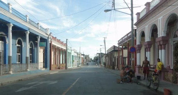
GuantánamoUNESCO
City · Guantánamo Province
Guantánamo is a municipality and city in southeast Cuba and capital of Guantánamo Province.
Text: Wikipedia (CC BY-SA 4.0). Photo: Leon Petrosyan (CC BY-SA 3.0). Map

Santiago de Cuba
City · Santiago de Cuba Province
Santiago de Cuba is the second-largest city in Cuba and the capital city of Santiago de Cuba Province. It lies in the southeastern part of the island, some 870 km (540 mi) southeast of the Cuban capital of Havana.
Text: Wikipedia (CC BY-SA 4.0). Photo: Glogg, Peter, Switzerland (CC BY 2.0). Map

Guantánamo Bay
Bahía de Guantánamo
Beach
Guantánamo Bay is a bay in Guantánamo Province at the southeastern end of Cuba. It is the largest harbor on the south side of the island and it is surrounded by steep hills which create an enclave that is cut off from its immediate hinterland.
Text: Wikipedia (CC BY-SA 4.0). Photo: Lithiumpilz (CC BY-SA 4.0). Map

Camagüey
City · Camagüey Province
Camagüey is a city and municipality in central Cuba and is the nation's third-largest city with more than 333,000 inhabitants. It is the capital of the Camagüey Province.
Text: Wikipedia (CC BY-SA 4.0). Photo: Wikimedia Commons: Camaguey rooftops 2.jpg (CC BY 2.5). Map
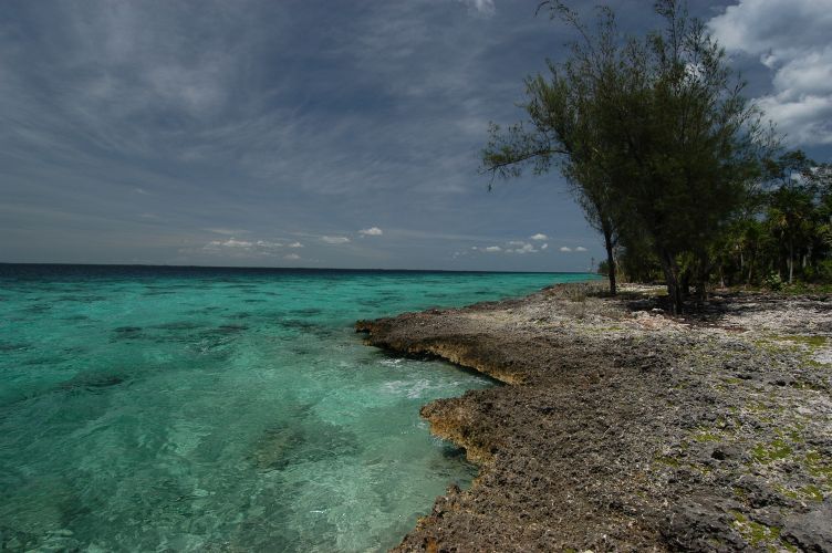
Bay of Pigs
Bahía de Cochinos
Beach · Matanzas Province
The Bay of Pigs is an inlet of the Gulf of Cazones, located on the southern coast of Cuba.
Text: Wikipedia (CC BY-SA 4.0). Photo: Vgenecr at Dutch Wikipedia (Public domain). Map


A few words in Spanish
From VoyaKin’s free Spanish lessons in the app, with audio there.
- HolaHello / Hi
- Buenos díasGood morning
- Buenas tardesGood afternoon
- Buenas nochesGood evening / Good night
- ¿Cómo está?How are you? (polite)
- Bien, gracias. ¿Y usted?Fine, thanks. And you?
- AdiósGoodbye
- Hasta luegoSee you later / Bye
Keep exploring
Also in Caribbean: Jamaica · Dominican Republic · Barbados · Bahamas · Anguilla · Antigua & Barbuda · Aruba · British Virgin Islands
Last updated November 12, 2026. Sources: Wikipedia (CC BY-SA 4.0), Wikimedia Commons, OpenStreetMap (ODbL). Partner offers below are separate from this guide and never change what’s written here.
Plan & book Cuba
Partner linksVoyaKin may earn a commission if you book through a partner link. It doesn’t change your price. How we work with partners
Flights
Kiwi.com
Search flights on Kiwi.com
Compare routes to and from this country.
Partner link. VoyaKin may earn a commission if you book through this link, at no extra cost to you.
eSIM & staying connected
Saily
Stay connected: get an eSIM before you fly.
VoyaKin travelers get US$5 off their first Saily plan with code VOYAKIN9122.
VoyaKin readers’ code
Partner link. VoyaKin may earn a commission if you book through this link, at no extra cost to you.
Partner linksVoyaKin may earn a commission if you book through a partner link. It doesn’t change your price. How we work with partners