Travel Hub
Plan a trip to Vanuatu

Vanuatu at a glance
Vanuatu is a country in Melanesia; its capital is Port Vila. People mainly speak Bislama, English and French. The currency is the Vanuatu Vatu (VUV). VoyaKin maps 18 places to see here, including 1 UNESCO World Heritage site.
- Flag
- 🇻🇺
- Capital
- Port Vila
- Region
- Melanesia
- Languages
- Bislama, English, French
- Currency
- Vanuatu Vatu (VUV)
- More
- Wikidata
Before you go: official information
Entry rules, visas and health requirements change. Confirm them with Vanuatu’s official immigration authority or its embassy before you book and again before you travel.
Check your own government’s travel advice before you go.
Places to see in Vanuatu
12 of the 18 places VoyaKin maps here. Descriptions from Wikipedia and photos from Wikimedia Commons, credited on each card.


Port Vila
City · Shefa
Port Vila, or simply Vila, is the capital of Vanuatu and its largest city. It is on the island of Efate, in Shefa Province. The population was 49,034 as of the 2020 Vanuatu census. This represented 16.3% of Vanuatu's total population in 2020.
Text: Wikipedia (CC BY-SA 4.0). Photo: Phillip Capper from Wellington, New Zealand (CC BY 2.0). Map

Espiritu Santo
Island · Sanma
Espiritu Santo, usually just called Santo, is the largest island in the nation and archipelago of Vanuatu, with an area of 3,955.5 km2 (1,527.2 sq mi), although Efate, on which the capital city of Port Vila is located, has a larger population. As of 2020, the population of Santo was 37,328.
Text: Wikipedia (CC BY-SA 4.0). Photo: NASA (Public domain). Map

Tanna
Island · Tafea
Tanna is an island in southern Vanuatu. Tanna is the most populous island of Tafea Province, and the third most populous in the country. It is home to five indigenous languages, which also rank among the most widely spoken in the whole archipelago, ranging from 3,500 to 11,500 speakers.
Text: Wikipedia (CC BY-SA 4.0). Photo: Charmaine Tham from Melbourne, Australia (CC BY 2.0). Map
Efate
Island · Shefa
Efate, originally named Sandwich Island and also known as Île Vate or just Vate, is an island in the Pacific Ocean. It is part of the Shefa Province in Vanuatu, and the capital city, Port Vila, is located on the island.
Text: Wikipedia (CC BY-SA 4.0). Photo: Phillip Capper from Wellington, New Zealand (CC BY 2.0). Map

Luganville
City · Sanma
Luganville is the second largest city in Vanuatu after the capital Port Vila; it is located on the island of Espiritu Santo and has a population of 17,719 as of the 2020 census.
Text: Wikipedia (CC BY-SA 4.0). Photo: Nikdarlington at English Wikipedia (Public domain). Map

Ambrym
Island · Malampa
Ambrym is a volcanic island in Malampa Province in the archipelago of Vanuatu. It is located near the center of the archipelago of Vanuatu, and also hosts one of the most active volcanoes in the world, which includes lava lakes in two craters near the summit.
Text: Wikipedia (CC BY-SA 4.0). Photo: Geophile71 (CC0). Map

Mount Yasur
Mountain · Tafea
Mount Yasur is an active volcano on Tanna Island, Vanuatu, 361 m (1,184 ft) high above sea level, on the coast near Sulphur Bay, northeast of the taller Mount Tukosmera, which was active in the Pleistocene.
Text: Wikipedia (CC BY-SA 4.0). Photo: Rolf Cosar (CC BY 2.5). Map
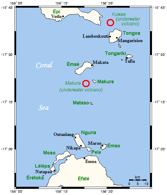
Kuwae
Kuwae Underwater Volcano
Mountain · Shefa Province
Kuwae was a landmass that existed in the vicinity of Tongoa and was destroyed by volcanic eruption in the fifteenth century, probably through caldera subsidence. Its exact location is debated.
Text: Wikipedia (CC BY-SA 4.0). Photo: Wikimedia Commons: ShepherdIslandsMap.png (CC BY-SA 3.0). Map

Manaro Voui
Lombenben - Manaro Voui
Mountain · Penama
Manaro Voui, or Manaro Vui, is a shield volcano whose emergent portion is known as the island of Ambae in Vanuatu. The summit is 1,496 metres (4,908 ft) above sea level and about 3,900 m (12,800 ft) above the sea floor.
Text: Wikipedia (CC BY-SA 4.0). Photo: NASA/JPL/NGA (Public domain). Map

Lake Letas
Lake · Torba
Lake Letas is the largest lake in Vanuatu, located in the center of the volcanic island of Gaua of the Banks Islands in northern Vanuatu. The place submitted an application to be considered an UNESCO World Heritage Site in 2004, and has been listed as a protected Ramsar site since 2023.
Text: Wikipedia (CC BY-SA 4.0). Photo: Bradwarden at English Wikipedia (CC BY-SA 3.0). Map

National Museum of Vanuatu
Musée National de Vanuatu
Museum · Shefa
The National Museum of Vanuatu is located in the Vanuatu Cultural Centre (VCC) in Port Vila, Vanuatu. It specializes in exhibits relating to the culture and history of this group of islands in the South Pacific.
Text: Wikipedia (CC BY-SA 4.0). Photo: PhillipC (CC BY 2.0). Map


Keep exploring
Also in Melanesia: Fiji · New Caledonia · Papua New Guinea · Solomon Islands
Last updated November 12, 2026. Sources: Wikipedia (CC BY-SA 4.0), Wikimedia Commons, OpenStreetMap (ODbL). Partner offers below are separate from this guide and never change what’s written here.
Plan & book Vanuatu
Partner linksVoyaKin may earn a commission if you book through a partner link. It doesn’t change your price. How we work with partners
Flights
Kiwi.com
Search flights on Kiwi.com
Compare routes to and from this country.
Partner link. VoyaKin may earn a commission if you book through this link, at no extra cost to you.
Tours & experiences
 3 hRarru Cascades, Waterfall & Kava 5.0 (53)From US$64 on Viator
 1 h1 hr Reef Explorer in Port Vila harbour, Vanuatu 5.0 (15)From US$45 on Viator
 8 hEfate Island Highlights 5.0 (12)From US$139 on Viator
 8 hMoso Blue Cave Day Tour 5.0 (11)From US$126 on Viator
 7 hPort Vila's Guided Food Experience 5.0 (10)From US$125 on Viator
 2.5 hDive Into Paradise: Snorkel Adventure at Paradise Cove 5.0 (10)From US$66 on Viator
 4 h–6 hTropical Splash Tour 5.0 (8)From US$100 on Viator
 3 h3-Hour Volcanic Signature Spa Package including Massage in Port Vila 5.0 (7)From US$179 on Viator
 6 hFull Day Tour Cascades Adventure, Turtles and Blue Lagoon 5.0 (7)From US$140 on Viator
 9 hFull Day Pele Island Boat Tour with Barbeque Lunch 5.0 (6)From US$125 on Viator
Partner links via Viator. Ratings, reviews and prices come from Viator and may change. VoyaKin may earn a commission if you book through a partner link. It doesn’t change your price.
eSIM & staying connected
Saily
Stay connected: get an eSIM before you fly.
VoyaKin travelers get US$5 off their first Saily plan with code VOYAKIN9122.
VoyaKin readers’ code
Partner link. VoyaKin may earn a commission if you book through this link, at no extra cost to you.
Partner linksVoyaKin may earn a commission if you book through a partner link. It doesn’t change your price. How we work with partners