Travel Hub
Plan a trip to Solomon Islands
Solomon Islands at a glance
Solomon Islands is a country in Melanesia; its capital is Honiara. People mainly speak English. The currency is the Solomon Islands Dollar (SBD). VoyaKin maps 14 places to see here, including 1 UNESCO World Heritage site.
- Flag
- 🇸🇧
- Capital
- Honiara
- Region
- Melanesia
- Languages
- English
- Currency
- Solomon Islands Dollar (SBD)
- More
- Wikidata
Before you go: official information
Entry rules, visas and health requirements change. Confirm them with Solomon Islands’s official immigration authority or its embassy before you book and again before you travel.
Check your own government’s travel advice before you go.
Places to see in Solomon Islands
12 of the 14 places VoyaKin maps here. Descriptions from Wikipedia and photos from Wikimedia Commons, credited on each card.
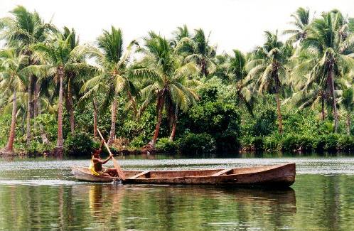
East RennellUNESCO
Island · Rennell and Bellona Province
East Rennell is the southern portion of Rennell Island in the Solomon Islands which is designated a UNESCO World Heritage Site. Rennell is the largest raised coral atoll in the world and the area in East Rennell surrounding Lake Tegano contains many endemic species.
Text: Wikipedia (CC BY-SA 4.0). Photo: Wikimedia Commons: Dugout canoe Rennell.jpg (Public domain). Map

Honiara
City · Guadalcanal Province
Honiara is the capital and largest city of Solomon Islands, situated on the northwestern coast of Guadalcanal. As of 2019, it had a population of 129,569 people. The city is served by Honiara International Airport and the seaport of Point Cruz, and lies along the Kukum Highway.
Text: Wikipedia (CC BY-SA 4.0). Photo: Xploredive cropped by Dr. Blofeld (CC BY 2.0). Map

Guadalcanal
Island · Guadalcanal Province
Guadalcanal is the principal island in the Guadalcanal Province of Solomon Islands, located in the southwestern Pacific Ocean, northeast of Australia. It is the largest island in the nation of Solomon Islands by both area and population, followed by Malaita.
Text: Wikipedia (CC BY-SA 4.0). Photo: StewyOz (CC BY-SA 4.0). Map

Malaita
Island · Malaita Province
Malaita is the primary island of Malaita Province in Solomon Islands. Malaita is the second most populous island of the Solomon Islands after Guadalcanal, with a population of 172,740 as of 2019, or slightly less than a quarter of the entire national population.
Text: Wikipedia (CC BY-SA 4.0). Photo: Wikimedia Commons: Malaita Island NASA.jpg (Public domain). Map


Auki
Town · Malaita Province
Auki, sometimes styled ʻAoke, is the provincial capital of Malaita Province in Solomon Islands. It is situated on the northern end of Langa Langa Lagoon on the north-west coast of Malaita.
Text: Wikipedia (CC BY-SA 4.0). Photo: Irene Scott/AusAID (CC BY 2.0). Map

Kavachi
Kavachi submarine volcano
Mountain · Western
Kavachi is one of the most active submarine volcanoes in the south-west Pacific Ocean. Located south of Vangunu Island in the Solomon Islands, it is named after a sea god of the New Georgia Group islanders and is also referred to locally as Rejo te Kavachi.
Text: Wikipedia (CC BY-SA 4.0). Photo: National Oceanic and Atmospheric Administration (Public domain). Map

Gizo
Town · Western Province
Gizo is the capital of the Western Province in Solomon Islands. The town had a population of 4,620 as of 2019. It is situated on Ghizo Island approximately 380 kilometres west-northwest of the capital, Honiara, and is just southwest of the larger island of Kolombangara.
Text: Wikipedia (CC BY-SA 4.0). Photo: Wikimedia Commons: Gizo Water front 3.jpg (Public domain). Map


Mount Veve
Kolombangara
Mountain · Western
Mount Veve is a dormant stratovolcano on the island of Kolombangara, in the Solomon Islands. With an elevation of 1,768 metres (5,801 ft), it is the island's highest point.
Text: Wikipedia (CC BY-SA 4.0). Photo: Wikimedia Commons: Kolombangara NASA.jpg (Public domain). Map

Point Cruz
Viewpoint · Guadalcanal Province
Point Cruz is a peninsula in the center of Honiara, on Guadalcanal Island. Honiara is the capital city of the Solomon Islands. Point Cruz is located on the Tandai Highway, and is ¼ mile north of the Solomon Islands Parliament Building.
Text: Wikipedia (CC BY-SA 4.0). Photo: Phenss (CC BY-SA 4.0). Map

Purvis Bay
Beach · Central Province
Purvis Bay is located in the Nggela Islands, part of the Solomon Islands. Purvis Bay is the sheltered area to the south of the island Nggela Sule, including and trending southeast from the neighbouring Tulagi islet.
Text: Wikipedia (CC BY-SA 4.0). Photo: National Archives 80-G-K-1581 (Public domain). Map


Keep exploring
Also in Melanesia: Fiji · New Caledonia · Papua New Guinea · Vanuatu
Last updated November 12, 2026. Sources: Wikipedia (CC BY-SA 4.0), Wikimedia Commons, OpenStreetMap (ODbL). Partner offers below are separate from this guide and never change what’s written here.
Plan & book Solomon Islands
Partner linksVoyaKin may earn a commission if you book through a partner link. It doesn’t change your price. How we work with partners
Flights
Kiwi.com
Search flights on Kiwi.com
Compare routes to and from this country.
Partner link. VoyaKin may earn a commission if you book through this link, at no extra cost to you.
Tours & experiences
 4.5 hHoniara City-Half Day City Tour 4.8 (13)From US$155 on Viator
 4.5 hEast Honiara Historic World War II Battlefields Tour 4.8 (29)From US$188 on Viator
 4 hHotomai Cultural Village Tour 5.0 (4)From US$185 on Viator
 30 min–1 hAirport Transfers from Honiara International Airport to Hotel 4.7 (6)From US$34 on Viator
 4 hThe Solomon Chocolate trailFrom US$460 on Viator
Partner links via Viator. Ratings, reviews and prices come from Viator and may change. VoyaKin may earn a commission if you book through a partner link. It doesn’t change your price.
eSIM & staying connected
Saily
Stay connected: get an eSIM before you fly.
VoyaKin travelers get US$5 off their first Saily plan with code VOYAKIN9122.
VoyaKin readers’ code
Partner link. VoyaKin may earn a commission if you book through this link, at no extra cost to you.
Partner linksVoyaKin may earn a commission if you book through a partner link. It doesn’t change your price. How we work with partners