Travel Hub
Plan a trip to Papua New Guinea

Papua New Guinea at a glance
Papua New Guinea is a country in Melanesia; its capital is Port Moresby. People mainly speak Tok Pisin, English and Hiri Motu. The currency is the Papua New Guinean Kina (PGK). VoyaKin maps 20 places to see here.
- Flag
- 🇵🇬
- Capital
- Port Moresby
- Region
- Melanesia
- Languages
- Tok Pisin, English, Hiri Motu
- Currency
- Papua New Guinean Kina (PGK)
- More
- Wikidata
Before you go: official information
Entry rules, visas and health requirements change. Confirm them with Papua New Guinea’s official immigration authority or its embassy before you book and again before you travel.
Check your own government’s travel advice before you go.
Places to see in Papua New Guinea
12 of the 20 places VoyaKin maps here. Descriptions from Wikipedia and photos from Wikimedia Commons, credited on each card.
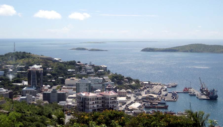
Port Moresby
City · National Capital District
Port Moresby, also referred to as Pom City or simply Moresby, is the capital and largest city of Papua New Guinea. It is one of the largest cities in the southwestern Pacific outside of Australia and New Zealand.
Text: Wikipedia (CC BY-SA 4.0). Photo: MSchlauch (Public domain). Map

New Britain
Island · West New Britain Province
New Britain is the largest island in the Bismarck Archipelago, part of the Islands Region of Papua New Guinea. It is separated from New Guinea by a northwest corner of the Solomon Sea and from New Ireland by St. George's Channel. The main towns of New Britain are Rabaul, Kokopo, and Kimbe.
Text: Wikipedia (CC BY-SA 4.0). Photo: Wikimedia Commons: Newbritain lrg.jpg (Public domain). Map

Bougainville Island
Island · Autonomous Region of Bougainville
Bougainville Island is the main island of the Autonomous Region of Bougainville, which is part of Papua New Guinea. Its land area is 9,384 km2 (3,623 sq mi). The highest point is Mount Balbi, on the main island, at 2,715 m (8,907 ft).
Text: Wikipedia (CC BY-SA 4.0). Photo: Jeremy Weate (CC BY 2.0). Map

Rabaul
City · East New Britain Province
Rabaul is a township in the East New Britain province of Papua New Guinea, on the island of New Britain. It lies about 600 km (370 mi) to the east of the island of New Guinea.
Text: Wikipedia (CC BY-SA 4.0). Photo: Stefan Krasowski from New York, NY, USA (CC BY 2.0). Map


Mount Wilhelm
Mountain · Jiwaka
Mount Wilhelm is the highest mountain in Papua New Guinea at 4,509 metres (14,793 ft). It is part of the Bismarck Range and the peak is the point where three provinces, Chimbu, Jiwaka and Madang, meet. In the local Kuman language, the peak is also known as Enduwa Kombuglu or Kombugl'o Dimbin.
Text: Wikipedia (CC BY-SA 4.0). Photo: Nomadtales (talk · contribs) (CC BY-SA 2.1 au). Map

Manus Island
Island · Manus Province
Manus Island is part of Manus Province in northern Papua New Guinea and is the largest of the Admiralty Islands. It is the fifth-largest island in Papua New Guinea, with an area of 2,100 km2 (810 sq mi), measuring around 100 km × 30 km.
Text: Wikipedia (CC BY-SA 4.0). Photo: NASA (Public domain). Map


Buka Island
Island · Autonomous Region of Bougainville
Buka Island is the second-largest island in the Autonomous Region of Bougainville, in eastern Papua New Guinea. It is in Buka Rural LLG of North Bougainville District, with the Autonomous Region's and district's capital city of Buka on the island.
Text: Wikipedia (CC BY-SA 4.0). Photo: user:Electionworld (CC BY-SA 3.0). Map

Tavurvur
Mountain · East New Britain Province
Tavurvur is an active stratovolcano near Rabaul, on the island of New Britain, in Papua New Guinea. It is a sub-vent of the Rabaul caldera and lies on the eastern rim of the larger feature. An eruption of the volcano largely destroyed the nearby town of Rabaul in 1994.
Text: Wikipedia (CC BY-SA 4.0). Photo: Taro Taylor edit by Richard Bartz (CC BY 2.0). Map

Ulawun
Mountain · West New Britain Province
Ulawun is an active stratovolcano in West New Britain Province, on the island of New Britain in Papua New Guinea.
Text: Wikipedia (CC BY-SA 4.0). Photo: Wikimedia Commons: Ulawun.jpg (Public domain). Map

Mount Giluwe
Mountain · Southern Highlands Province
Mount Giluwe is the second highest mountain in Papua New Guinea at 4,367 metres (14,327 ft), and the fifth highest peak on the island of New Guinea. It is located in the Southern Highlands province and is an old shield volcano with vast alpine grasslands.
Text: Wikipedia (CC BY-SA 4.0). Photo: Kaijankoski (CC0). Map


Keep exploring
Also in Melanesia: Fiji · New Caledonia · Solomon Islands · Vanuatu
Last updated November 12, 2026. Sources: Wikipedia (CC BY-SA 4.0), Wikimedia Commons, OpenStreetMap (ODbL). Partner offers below are separate from this guide and never change what’s written here.
Plan & book Papua New Guinea
Partner linksVoyaKin may earn a commission if you book through a partner link. It doesn’t change your price. How we work with partners
Flights
Kiwi.com
Search flights on Kiwi.com
Compare routes to and from this country.
Partner link. VoyaKin may earn a commission if you book through this link, at no extra cost to you.
Tours & experiences
 288 hADVENTURE KOKODA 10-Day Premium Kokoda Campaign Trek Australian Led 5.0 (89)From US$3,628 on Viator
 240 hADVENTURE KOKODA 8 Day History Trek Australian Led 5.0 (316)From US$3,209 on Viator
 264 h11 Day Kokoda Trek From Port Moresby 4.9 (20)From US$3,348 on Viator
 4 hCultural and Local Village Experience in Papua New Guinea 4.1 (29)From US$80 on Viator
 31 hPrivate Port Moresby City Tour 4.0 (21)From US$350 on Viator
 3 hRabaul Highlights Tour 3.9 (15)From US$66 on Viator
 5 hEastcape Drive Tour 3.4 (16)From US$154 on Viator
 264 h11 Day Kokoda Trek Australian and Local Guides 5.0 (7)From US$3,352 on Viator
 120 h5-Day Island Adventure in Milne Bay Province, Papua New Guinea 5.0 (2)From US$4,000 on Viator
 240 hADVENTURE KOKODA 8 Day Kokoda Trail Trek 4.9 (8)From US$2,231 on Viator
Partner links via Viator. Ratings, reviews and prices come from Viator and may change. VoyaKin may earn a commission if you book through a partner link. It doesn’t change your price.
eSIM & staying connected
Saily
Stay connected: get an eSIM before you fly.
VoyaKin travelers get US$5 off their first Saily plan with code VOYAKIN9122.
VoyaKin readers’ code
Partner link. VoyaKin may earn a commission if you book through this link, at no extra cost to you.
Partner linksVoyaKin may earn a commission if you book through a partner link. It doesn’t change your price. How we work with partners