Travel Hub
Plan a trip to Cape Verde

Cape Verde at a glance
Cape Verde is a country in Western Africa; its capital is Praia. People mainly speak Portuguese. The currency is the Cape Verdean Escudo (CVE). VoyaKin maps 20 places to see here, including 3 UNESCO World Heritage sites.
- Flag
- 🇨🇻
- Capital
- Praia
- Region
- Western Africa
- Languages
- Portuguese
- Currency
- Cape Verdean Escudo (CVE)
- More
- Wikidata
Before you go: official information
Entry rules, visas and health requirements change. Confirm them with Cape Verde’s official immigration authority or its embassy before you book and again before you travel.
Check your own government’s travel advice before you go.
Places to see in Cape Verde
12 of the 20 places VoyaKin maps here. Descriptions from Wikipedia and photos from Wikimedia Commons, credited on each card.

Cidade VelhaUNESCO
Ribeira Grande de Santiago (Cidade Velha)
Town · Sotavento Islands
Cidade Velha is a city in the southern part of the island of Santiago, Cape Verde. Founded in 1462 by Portuguese traders, it is the oldest settlement in Cape Verde and its former capital.
Text: Wikipedia (CC BY-SA 4.0). Photo: Ji-Elle (CC BY-SA 3.0). Map

Nossa Senhora do Rosário churchUNESCO
Religious · Sotavento Islands
Nossa Senhora do Rosario church is a 15th century church in the town of Cidade Velha on the island of Santiago, Cape Verde. It is located in the northwest of the town, near the right (west) bank of the stream Ribeira Grande de Santiago.
Text: Wikipedia (CC BY-SA 4.0). Photo: Ji-Elle (CC BY-SA 3.0). Map


Praia
City · Sotavento Islands
Praia is the capital and largest city of Cape Verde. Located on the southern coast of Santiago island within the Sotavento Islands group, the city is the seat of the Praia Municipality. Praia is the political, economic and cultural center of Cape Verde.
Text: Wikipedia (CC BY-SA 4.0). Photo: Xandu (Public domain). Map

Santiago
Island · Santa Catarina
Santiago is the largest island of Cape Verde, its most important agricultural centre and home to half the nation's population. Part of the Sotavento Islands, it lies between the islands of Maio and Fogo. It was the first of the islands to be settled: the town of Ribeira Grande was founded in 1462.
Text: Wikipedia (CC BY-SA 4.0). Photo: Wikimedia Commons: FamilieInTarrafalKapverden.jpg (Public domain). Map

Sal
Ilha do Sal
Island · Barlavento Islands
Sal is an island in Cape Verde. Sal is a tourist destination with white sand beaches and over 350 days of sunshine a year. It is one of the three sandy eastern islands of the Cape Verde archipelago in the central Atlantic Ocean, 350 miles (560 km) off the west coast of Africa.
Text: Wikipedia (CC BY-SA 4.0). Photo: Martikkk (CC BY-SA 3.0). Map

Mindelo
City · Barlavento Islands
Mindelo is a port city in the northern part of the island of São Vicente in Cape Verde. Mindelo is also the seat of the parish of Nossa Senhora da Luz, and the municipality of São Vicente.
Text: Wikipedia (CC BY-SA 4.0). Photo: Manuel de Sousa (CC BY-SA 3.0). Map

São Vicente
Island · Barlavento Islands
São Vicente is one of the Barlavento Islands, the northern group within the Cape Verde archipelago in the Atlantic Ocean, off the West African coast. It is located between the islands of Santo Antão and Santa Luzia, with the Canal de São Vicente separating it from Santo Antão.
Text: Wikipedia (CC BY-SA 4.0). Photo: Kotoviski (Henryk Kotowski) (CC BY-SA 3.0). Map
Boa Vista
Island · Barlavento Islands
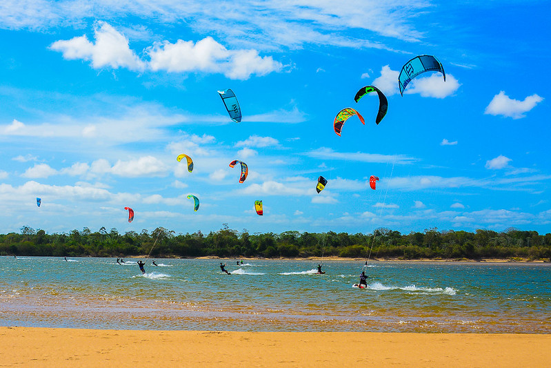
Boa Vista, sometimes spelled Boavista, is a desert-like island that belongs to the Cape Verde Islands. At 631 km2 (244 sq mi), it is the third largest island of the Cape Verde archipelago.
Text: Wikipedia (CC BY-SA 4.0). Photo: Andrezza Mariot (CC BY-SA 4.0). Map

Pico do Fogo
Crater Pico de Fogo
Mountain · Sotavento Islands
Pico do Fogo is an active stratovolcano located on the island of Fogo, Cape Verde, rising to 2,829 metres (9,281 ft) above sea level. The main cone last erupted in 1680, causing mass emigration from the island. A subsidiary vent erupted in 1995.
Text: Wikipedia (CC BY-SA 4.0). Photo: Holger Reineccius (CC BY-SA 3.0). Map

Espargos
Town · Barlavento Islands
Espargos is the capital and main commercial centre of the island and municipality of Sal, Cape Verde. The city is situated in the heart of the island.
Text: Wikipedia (CC BY-SA 4.0). Photo: Ingo Wölbern (Public domain). Map

Tarrafal concentration camp
Museu do Campo de Concentração do Tarrafal
Museum · Sotavento Islands
Tarrafal was a concentration camp located in the village of Chão Bom, in the Municipality of Tarrafal, on the island of Santiago in Cape Verde.
Text: Wikipedia (CC BY-SA 4.0). Photo: Gagum from Lisbon, Portugal (CC BY 2.0). Map


Keep exploring
Also in Western Africa: Ghana · Senegal · Benin · Burkina Faso · Côte d’Ivoire · Gambia · Guinea · Guinea-Bissau
Last updated November 12, 2026. Sources: Wikipedia (CC BY-SA 4.0), Wikimedia Commons, OpenStreetMap (ODbL). Partner offers below are separate from this guide and never change what’s written here.
Plan & book Cape Verde
Partner linksVoyaKin may earn a commission if you book through a partner link. It doesn’t change your price. How we work with partners
Flights
Kiwi.com
Search flights on Kiwi.com
Compare routes to and from this country.
Partner link. VoyaKin may earn a commission if you book through this link, at no extra cost to you.
Tours & experiences
 6 h–7 hExcursion Volta Island full tour 5.0 (63)From US$59 on Viator
 3 hRomantic Sunset & Glamping Experience 5.0 (43)From US$152 on Viator
 7 hIsland of the Salt Back to the Island in Pick Up 5.0 (39)From US$34 on Viator
 4 h–7 hPrivate Tour to Sal Island Personalized Experience for Group 5.0 (35)From US$294 on Viator
 6 h–8 hPrivate Creative Pictures Full Day Island Tour (Off Road inc.) 5.0 (31)From US$96 on Viator
 4 h–5 hLike Locals: Praia and Cidade Velha Tour + Local Pontxi Tasting 5.0 (21)From US$62 on Viator
 4 hWalking tour with traditional music in Mindelo 5.0 (20)From US$108 on Viator
 2 h–3 hDesova of the Marine Turtles Careta-Careta 5.0 (18)From US$51 on Viator
 3 h–4 hGuided City tour Praia with Cidade Velha (World Heritage) 5.0 (18)From US$55 on Viator
 8 hFull Day Adults Only Tour of Sal with Lobster Lunch and Salt Lake 5.0 (16)From US$134 on Viator
Partner links via Viator. Ratings, reviews and prices come from Viator and may change. VoyaKin may earn a commission if you book through a partner link. It doesn’t change your price.
eSIM & staying connected
Saily
Stay connected: get an eSIM before you fly.
VoyaKin travelers get US$5 off their first Saily plan with code VOYAKIN9122.
VoyaKin readers’ code
Partner link. VoyaKin may earn a commission if you book through this link, at no extra cost to you.
Partner linksVoyaKin may earn a commission if you book through a partner link. It doesn’t change your price. How we work with partners