Travel Hub
Plan a trip to Benin

Benin at a glance
Benin is a country in Western Africa; its capital is Porto-Novo. People mainly speak French. The currency is the West African CFA Franc (XOF). VoyaKin maps 19 places to see here, including 3 UNESCO World Heritage sites.
- Flag
- 🇧🇯
- Capital
- Porto-Novo
- Region
- Western Africa
- Languages
- French
- Currency
- West African CFA Franc (XOF)
- More
- Wikidata
Before you go: official information
Entry rules, visas and health requirements change. Confirm them with Benin’s official immigration authority or its embassy before you book and again before you travel.
Check your own government’s travel advice before you go.
Places to see in Benin
12 of the 19 places VoyaKin maps here. Descriptions from Wikipedia and photos from Wikimedia Commons, credited on each card.

KoutammakouUNESCO
Koutammakou Land
Town · Kara Region
Koutammakou, the Land of the Batammariba is a cultural landscape designated in 2004 and expanded in 2023 as a UNESCO World Heritage Site at the border between northern Togo and Benin. The area features traditional mud tower-houses which remain the preferred style of living.
Text: Wikipedia (CC BY-SA 4.0). Photo: Erik Kristensen (CC BY 2.0). Map

Pendjari National ParkUNESCO
Parc National de la Pendjari
Park & nature · Atakora Department
Pendjari National Park lies in north-western Benin, adjoining the Arli National Park in Burkina Faso.
Text: Wikipedia (CC BY-SA 4.0). Photo: Fawaz.tairou (CC BY-SA 3.0). Map

Porto-Novo
City · Ouémé Department
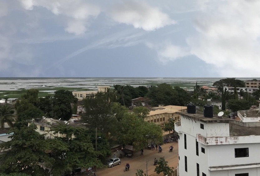
Porto-Novo is the capital and second-largest city of Benin. The commune covers an area of 52 square kilometres (20 sq mi) and as of 2013 had a population of 264,320 people.
Text: Wikipedia (CC BY-SA 4.0). Photo: Élisée.Adad (CC BY-SA 4.0). Map

Cotonou
City · Littoral
Cotonou is the seat of government and largest city of Benin. The official city proper population was 679,012 in 2012; however, over two million people live in the larger urban area. The urban area continues to expand, notably toward the west.
Text: Wikipedia (CC BY-SA 4.0). Photo: Adoscam (CC BY-SA 4.0). Map


Lake Nokoué
Lac Nokoué
Lake · Atlantique Department
Lake Nokoué is a lake in the southern part of Benin. It is 20 km (12 mi) wide and 11 km (6.8 mi) long and covers an area of 4,900 ha. The lake is partly fed by the Ouémé River and the Sô River, both of which deposit sediments from throughout the region in the lake.
Text: Wikipedia (CC BY-SA 4.0). Photo: NASA (Public domain). Map

Fort of São João Baptista de Ajudá
Fort Saint-Jean-Baptiste-d'Ajuda
Fort · Atlantique Department
The Forte de São João Baptista de Ajudá is a small restored fort in Ouidah, Benin. Built in 1721, it was the last of three European forts built in that town to tap the slave trade of the Slave Coast.
Text: Wikipedia (CC BY-SA 4.0). Photo: French naval officer, 1890 (Public domain). Map

Mont Sokbaro
Mountain · Donga Department
Mont Sokbaro is a mountain that is mostly cited as the highest point of Benin, with an elevation of 658 metres (2,159 ft). This designation is contested, as SRTM readings at coordinates 10°17′22″N 1°32′38″E give an elevation of 672 metres (2,205 ft).
Text: Wikipedia (CC BY-SA 4.0). Photo: Wikimedia Commons: Mont Sokbaro Cropped.jpg (CC BY-SA 4.0). Map

Amazon Monument
L'Amazone
Memorial · Littoral
The Amazon Monument is a statue honoring the Dahomey Amazons. A metal structure covered in bronze, it is 30m high and weighs 150 tons. It stands on the Esplanade des Amazones in the 12th district of the city of Cotonou in southern Benin. It is the second tallest statue in Africa.
Text: Wikipedia (CC BY-SA 4.0). Photo: Alfrednadjere (CC BY-SA 4.0). Map

Lake Ahémé
Lac Ahémé
Lake · Atlantique Department
Lake Ahémé is Benin's second largest lake, with an area of 78 square kilometres (30 sq mi) in the dry season which expands to 100 square kilometres (39 sq mi) in the rainy season. The lake is 24 kilometres (15 mi) long and has an average width of 3.6 kilometres (2.2 mi).
Text: Wikipedia (CC BY-SA 4.0). Photo: Adoscam (CC BY-SA 4.0). Map

Cotonou Cathedral
Notre-Dame de Miséricorde
Religious · Littoral
The cathedral of Notre Dame de Miséricorde, commonly known as Cotonou Cathedral, is a Catholic cathedral located near the Ancien Pont bridge in Cotonou, Benin. It is renowned for its distinctive burgundy and white striped tiled architecture.


Keep exploring
Also in Western Africa: Ghana · Senegal · Burkina Faso · Cape Verde · Côte d’Ivoire · Gambia · Guinea · Guinea-Bissau
Last updated November 12, 2026. Sources: Wikipedia (CC BY-SA 4.0), Wikimedia Commons, OpenStreetMap (ODbL). Partner offers below are separate from this guide and never change what’s written here.
Plan & book Benin
Partner linksVoyaKin may earn a commission if you book through a partner link. It doesn’t change your price. How we work with partners
Flights
Kiwi.com
Search flights on Kiwi.com
Compare routes to and from this country.
Partner link. VoyaKin may earn a commission if you book through this link, at no extra cost to you.
Stays
Partner links via Wink. Rooms, prices and availability are shown on Wink’s site.
Tours & experiences
 7 h–8 hPrivate Full-Day Cultural Tour in Cotonou Ganvie and Ouidah 4.5 (15)From US$289 on Viator
 5 h–7 hZangbeto Dance and Cultural Tour in Ouidah 5.0 (4)From US$289 on Viator
 5 hCotonou Private Tour 5.0 (3)From US$260 on Viator
 5 hHalf Day Cultural Tour of Ganvié The Venice of Africa 5.0 (3)From US$200 on Viator
 1 h–3 hGuided tour of the essentials in Ouidah! 5.0 (2)From US$56 on Viator
 2.5 hPainting Experience in Cotonou 5.0 (2)From US$59 on Viator
 336 hBenin, Togo and Ghana Private 14 Day Tour 5.0 (1)From US$4,605 on Viator
 240 h10-Day Tour: At the Heart of the Vodou Festival in Benin & Togo 5.0 (1)From US$3,747 on Viator
 1 h–8 hOuidah Slave Route and Door of No Return Day Tour from Cotonou 5.0 (1)From US$226 on Viator
 6 hOuidah full-day electric bike tour EN 5.0 (1)From US$111 on Viator
Partner links via Viator. Ratings, reviews and prices come from Viator and may change. VoyaKin may earn a commission if you book through a partner link. It doesn’t change your price.
eSIM & staying connected
Saily
Stay connected: get an eSIM before you fly.
VoyaKin travelers get US$5 off their first Saily plan with code VOYAKIN9122.
VoyaKin readers’ code
Partner link. VoyaKin may earn a commission if you book through this link, at no extra cost to you.
Partner linksVoyaKin may earn a commission if you book through a partner link. It doesn’t change your price. How we work with partners