Travel Hub
Plan a trip to Greenland

Greenland at a glance
Greenland is a territory in Northern America; its capital is Nuuk. People mainly speak Kalaallisut. The currency is the Danish Krone (DKK). VoyaKin maps 20 places to see here, including 2 UNESCO World Heritage sites.
- Flag
- 🇬🇱
- Capital
- Nuuk
- Region
- Northern America
- Languages
- Kalaallisut
- Currency
- Danish Krone (DKK)
- More
- Wikidata
Before you go: official information
Entry rules, visas and health requirements change. Confirm them with Greenland’s official immigration authority or its embassy before you book and again before you travel.
Check your own government’s travel advice before you go.
Places to see in Greenland
12 of the 20 places VoyaKin maps here. Descriptions from Wikipedia and photos from Wikimedia Commons, credited on each card.

Ilulissat IcefjordUNESCO
Kangiata Sullua
Beach
Ilulissat Icefjord is a fjord in western Greenland. Located 250 km north of the Arctic Circle, the Ilulissat Icefjord runs west 40 km (25 mi) from the Greenland ice sheet to Disko Bay just south of the town of Ilulissat.
Text: Wikipedia (CC BY-SA 4.0). Photo: Wikimedia Commons: Greenland Ilulissat1.jpg (CC BY-SA 3.0). Map

Aasivissuit – Nipisat: Inuit Hunting Ground between Ice and SeaUNESCO
Landmark
Aasivissuit – Nipisat: Inuit Hunting Ground between Ice and Sea is a cultural landscape and UNESCO World Heritage Site located in the central part of Western Greenland.
Text: Wikipedia (CC BY-SA 4.0). Photo: Chmee2/Valtameri (CC BY 3.0). Map

Nuuk
City
Nuuk is the capital and most populous city of Greenland, an autonomous territory of Denmark. It is the seat of the Sermersooq municipality and the government of Greenland and is the territory's largest cultural and economic center.
Text: Wikipedia (CC BY-SA 4.0). Photo: patano (CC BY-SA 3.0). Map

Ilulissat
Town
Ilulissat, also known as Jakobshavn or Jacobshavn, is the municipal seat and largest town of the Avannaata municipality in western Greenland, located approximately 350 km (220 mi) north of the Arctic Circle.
Text: Wikipedia (CC BY-SA 4.0). Photo: Vincent van Zeijst (CC BY 3.0). Map

Hans Island
Tartupaluk ᑕᕐᑐᐸᓗᒃ / Hans Ø / Hans Island / Île Hans
Island
Hans Island is an island in the centre of the Kennedy Channel of the Nares Strait in the high Arctic region, split between the Canadian territory of Nunavut and the Danish rigsdel of Greenland.
Text: Wikipedia (CC BY-SA 4.0). Photo: Toubletap (CC BY-SA 3.0). Map

Sisimiut
Town
Sisimiut, also known by its Danish name Holsteinsborg, is the capital and largest city of the Qeqqata municipality, and the second-largest city in Greenland. It is located in central-western Greenland, on the coast of Davis Strait, approximately 320 km (200 mi) north of Nuuk.
Text: Wikipedia (CC BY-SA 4.0). Photo: Chmee2/Valtameri (CC BY 3.0). Map

Qaanaaq
Town
Qaanaaq, formerly known as New Thule, is the main town in the northern part of the Avannaata municipality in northwestern Greenland. The town has a population of 586 as of 2026.
Text: Wikipedia (CC BY-SA 4.0). Photo: Col. Lee-Volker Cox (Public domain). Map

Kaffeklubben Island
Inuit Qeqertaat
Island
Kaffeklubben Island or Coffee Club Island is an uninhabited island lying off the northern shore of Greenland. It contains the northernmost undisputed point of land on Earth.
Text: Wikipedia (CC BY-SA 4.0). Photo: Not mentioned at the source (CC BY 2.0). Map

Gunnbjørn Fjeld
Mountain
Gunnbjørn Fjeld is the highest mountain in Greenland, north of the Arctic Circle, and the highest point in North America not on the mainland. It is situated in the east of the territory. It is a nunatak, a rocky peak protruding through glacial ice.
Text: Wikipedia (CC BY-SA 4.0). Photo: Maxim Bouev (CC0). Map
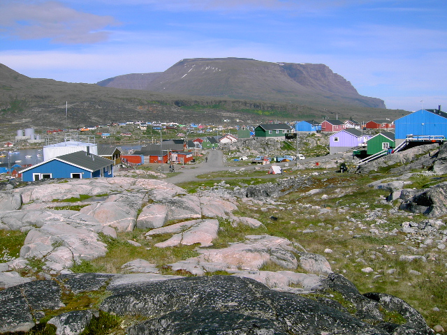
Disko Island
Qeqertarsuaq
Island
Disko Island is a large island in Baffin Bay, off the west coast of Greenland. It has an area of 8,578 km2 (3,312 mi2), making it the second largest island of Greenland, and one of the 100 largest islands in the world.
Text: Wikipedia (CC BY-SA 4.0). Photo: Makemake at German Wikipedia (CC BY-SA 3.0). Map

Cape Farewell
Uummannarsuaq
Viewpoint
Cape Farewell is a headland on the southern shore of Egger Island, Nunap Isua Archipelago, Greenland. As the southernmost point of the country, it is one of the important landmarks of Greenland.
Text: Wikipedia (CC BY-SA 4.0). Photo: Wikimedia Commons: Cape farewell greenland landsat.jpg (Public domain). Map


Keep exploring
Also in Northern America: Bermuda · Canada · St. Pierre & Miquelon · United States
Last updated November 12, 2026. Sources: Wikipedia (CC BY-SA 4.0), Wikimedia Commons, OpenStreetMap (ODbL). Partner offers below are separate from this guide and never change what’s written here.
Plan & book Greenland
Partner linksVoyaKin may earn a commission if you book through a partner link. It doesn’t change your price. How we work with partners
Flights
Kiwi.com
Search flights on Kiwi.com
Compare routes to and from this country.
Partner link. VoyaKin may earn a commission if you book through this link, at no extra cost to you.
Tours & experiences
 2 hChasing Northern Lights in Nuuk 5.0 (17)From US$450 on Viator
 1.5 hNuuk Greenland Private Guided Tour by Car 4.6 (32)From US$412 on Viator
 1 h–1.5 hNuuk Legends and History Smartphone Guided GPS Walking Tour 3.9 (18)From US$10 on Viator
 1 h–1.5 hQaqortoq Cultural Treasures Smartphone Guided GPS Walking Tour 3.1 (35)From US$10 on Viator
 2 hPrivate Historic Nuuk Walking Tour with Cultural Landmarks 5.0 (7)From US$519 on Viator
 15 min–30 minPrivate Transfer from Nuuk Airport to Nuuk City Center & Hotels 5.0 (4)From US$229 on Viator
 2 hNuuk Qinngorput Walk & Greenlandic Tea Hygge Experience 5.0 (2)From US$305 on Viator
 2 hNuuk Walking Tour with Greenlandic Beers and Arctic Burgers 5.0 (2)From US$305 on Viator
 15 minNuuk Hotels to Nuuk Airport (GOH) Departure Private Transfer 5.0 (1)From US$113 on Viator
 40 minPrivate Transfer from Helsinki Port to Helsinki Airport (HEL) 5.0 (1)From US$65 on Viator
Partner links via Viator. Ratings, reviews and prices come from Viator and may change. VoyaKin may earn a commission if you book through a partner link. It doesn’t change your price.
eSIM & staying connected
Saily
Stay connected: get an eSIM before you fly.
VoyaKin travelers get US$5 off their first Saily plan with code VOYAKIN9122.
VoyaKin readers’ code
Partner link. VoyaKin may earn a commission if you book through this link, at no extra cost to you.
Partner linksVoyaKin may earn a commission if you book through a partner link. It doesn’t change your price. How we work with partners