Travel Hub
Plan a trip to Canada

Canada at a glance
Canada is a country in Northern America; its capital is Ottawa. People mainly speak English and French. The currency is the Canadian Dollar (CAD). VoyaKin maps 20 places to see here, including 8 UNESCO World Heritage sites.
- Flag
- 🇨🇦
- Capital
- Ottawa
- Region
- Northern America
- Languages
- English, French
- Currency
- Canadian Dollar (CAD)
- More
- Wikidata
Before you go: official information
Entry rules, visas and health requirements change. Confirm them with Canada’s official immigration authority or its embassy before you book and again before you travel.
Check your own government’s travel advice before you go.
Places to see in Canada
12 of the 20 places VoyaKin maps here. Descriptions from Wikipedia and photos from Wikimedia Commons, credited on each card.


L'Anse aux MeadowsUNESCO
L’Anse aux Meadows National Historic Site
Ruins · Newfoundland and Labrador
L'Anse aux Meadows is an archaeological site, first excavated in the 1960s, of a Norse settlement dating to approximately 1,000 years ago. The site is located near St. Anthony on the northernmost tip of the island of Newfoundland in the Canadian province of Newfoundland and Labrador.
Text: Wikipedia (CC BY-SA 4.0). Photo: Dylan Kereluk from White Rock, Canada (CC BY 2.0). Map

Quebec CityUNESCO
City · Quebec
Quebec City is the capital city of the Canadian province of Quebec. As of 2026, the city has a population of 595,190 and the Quebec City census metropolitan area had a population of 839,311 in 2021. It is the twelfth-largest city and the seventh-largest metropolitan area in Canada.
Text: Wikipedia (CC BY-SA 4.0). Photo: Fabian Roudra Baroi (CC BY-SA 4.0). Map

Nahanni National Park ReserveUNESCO
Park & nature · Northwest Territories
The Nahanni National Park Reserve, sometimes known as "Headless Valley" or "Valley of The Headless Men", in the Dehcho Region of the Northwest Territories, Canada, protects a portion of the Mackenzie Mountains Natural Region. The centrepiece of the park is the South Nahanni River.
Text: Wikipedia (CC BY-SA 4.0). Photo: Paul Gierszewski (Public domain). Map

Wood Buffalo National ParkUNESCO
Park & nature · Northwest Territories
Wood Buffalo National Park is the largest national park of Canada at 44,741 km2 (17,275 sq mi). It is in northeastern Alberta and the southern Northwest Territories. Larger in area than Switzerland, it is the second-largest national park in the world.
Text: Wikipedia (CC BY-SA 4.0). Photo: Wikimedia Commons: Wood-Buffalo-NP Waldbison 98-07-02.jpg (CC BY-SA 2.5). Map

Gros Morne National ParkUNESCO
Park & nature · Newfoundland and Labrador
Gros Morne National Park is a Canadian national park and World Heritage Site located on the west coast of Newfoundland. At 1,805 km2 (697 sq mi), it is the second largest national park in Atlantic Canada after Torngat Mountains National Park, which has an area of 9,700 km2 (3,700 sq mi).
Text: Wikipedia (CC BY-SA 4.0). Photo: Adavyd (CC BY-SA 4.0). Map

Rideau CanalUNESCO
Lake · Ontario
The Rideau Canal is a 202-kilometre long canal that links the Ottawa River at Ottawa with the Cataraqui River and Lake Ontario at Kingston, Ontario, Canada.
Text: Wikipedia (CC BY-SA 4.0). Photo: Bobak Ha'Eri (CC BY-SA 2.5). Map

Head-Smashed-In Buffalo JumpUNESCO
Ruins · Alberta
Head-Smashed-In Buffalo Jump is a museum of Blackfoot culture 18 kilometres (11 mi) west of Fort Macleod, Alberta, Canada. The now disused buffalo jump is a UNESCO world heritage site in an area where the foothills of the Rocky Mountains begin to rise from the prairie.
Text: Wikipedia (CC BY-SA 4.0). Photo: Ken Thomas (Public domain). Map


Ottawa
City · Ontario
Ottawa is the capital city of Canada. It is located in the southeastern portion of the province of Ontario, at the confluence of the Ottawa River and the Rideau River.
Text: Wikipedia (CC BY-SA 4.0). Photo: Allice Hunter (CC BY-SA 4.0). Map
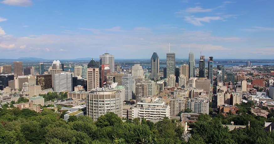
Montreal
City · Quebec
Montreal is the largest city in the province of Quebec, the second-largest in Canada, and the eighth-largest in North America. Founded in 1642 as Ville-Marie, or "City of Mary", it now takes its name from Mount Royal, the triple-peaked mountain around which the early settlement was built.
Text: Wikipedia (CC BY-SA 4.0). Photo: Wikimedia Commons: Montreal-canada-parc-urban.jpg (CC0). Map

Niagara Falls
Waterfall · Ontario
Niagara Falls is a group of three waterfalls at the southern end of Niagara Gorge, spanning the border between the Canadian province of Ontario and the U.S. state of New York. The largest of the three is Horseshoe Falls, which straddles the international border of the two countries.
Text: Wikipedia (CC BY-SA 4.0). Photo: Robert F. Tobler (CC BY-SA 4.0). Map


Keep exploring
Also in Northern America: Bermuda · Greenland · St. Pierre & Miquelon · United States
Last updated November 12, 2026. Sources: Wikipedia (CC BY-SA 4.0), Wikimedia Commons, OpenStreetMap (ODbL). Partner offers below are separate from this guide and never change what’s written here.
Plan & book Canada
Partner linksVoyaKin may earn a commission if you book through a partner link. It doesn’t change your price. How we work with partners
Flights
Kiwi.com
Search flights on Kiwi.com
Compare routes to and from this country.
Partner link. VoyaKin may earn a commission if you book through this link, at no extra cost to you.
Stays
Partner links via Wink. Rooms, prices and availability are shown on Wink’s site.
Tours & experiences
 7 h–9 hTour of Niagara Falls (Niagara Falls) 5.0 (176)From US$158 on Viator
 10 h–11 h12 Iconic Stops: Banff & Yoho Premium Small Group Guided Tour 5.0 (170)From US$150 on Viator
 9 h–12 hExplore Peyto, Bow & Emerald Lakes, Takakkaw Falls, Banff & Yoho 5.0 (162)From US$75 on Viator
 4 hAdrenaline Canyoning Tour Kelowna - Falls, Rappelling & Adventure 5.0 (118)From US$175 on Viator
 2.5 hVancouver Sailing Experience on a 50 Foot Sailboat 5.0 (114)From US$113 on Viator
 8 h–11 hPrivate Premium Custom Banff Tour Moraine Lake Louise 10 Spots 5.0 (82)From US$790 on Viator
 20 minHelicopter Tour Over Mont-Tremblant 70KM ( 20 min ) 5.0 (81)From US$156 on Viator
 8 h–10 hBanff National Park and Lake Louise Small Group Tour 5.0 (80)From US$53 on Viator
 9 h–11 hPrivate VIP Banff Tour: Lake Louise, Moraine Lake & Hidden Gems 5.0 (73)From US$718 on Viator
 8 hIcefields Parkway and Ice Bubbles of Abraham Lake Tour 5.0 (66)From US$208 on Viator
Partner links via Viator. Ratings, reviews and prices come from Viator and may change. VoyaKin may earn a commission if you book through a partner link. It doesn’t change your price.
eSIM & staying connected
Saily
Stay connected: get an eSIM before you fly.
VoyaKin travelers get US$5 off their first Saily plan with code VOYAKIN9122.
VoyaKin readers’ code
Partner link. VoyaKin may earn a commission if you book through this link, at no extra cost to you.
Partner linksVoyaKin may earn a commission if you book through a partner link. It doesn’t change your price. How we work with partners