Travel Hub
Plan a trip to Bhutan

Bhutan at a glance
Bhutan is a country in Southern Asia; its capital is Thimphu. People mainly speak Dzongkha. The currency is the Bhutanese Ngultrum (BTN). VoyaKin maps 19 places to see here.
- Flag
- 🇧🇹
- Capital
- Thimphu
- Region
- Southern Asia
- Languages
- Dzongkha
- Currency
- Bhutanese Ngultrum (BTN)
- More
- Wikidata
Before you go: official information
Entry rules, visas and health requirements change. Confirm them with Bhutan’s official immigration authority or its embassy before you book and again before you travel.
Check your own government’s travel advice before you go.
Places to see in Bhutan
12 of the 19 places VoyaKin maps here. Descriptions from Wikipedia and photos from Wikimedia Commons, credited on each card.

Thimphu
ཐིམ་ཕུག
City · Thimphu District
Thimphu is the capital and largest city of Bhutan. It is situated in the western central part of Bhutan, and the surrounding valley is one of Bhutan's dzongkhags, the Thimphu District.
Text: Wikipedia (CC BY-SA 4.0). Photo: Gerd Eichmann (CC BY-SA 4.0). Map

Gangkhar Puensum
岗嘎本松峰 གངས་དཀར་སྤུན་གསུམ་
Mountain · Gasa District
Gangkhar Puensum is the highest mountain in Bhutan and the highest unclimbed mountain in the world, with an elevation of 7,570 metres (24,836 ft) and a prominence of 2,995 metres (9,826 ft). In the Dzongkha language, its name means "White Peak of the Three Spiritual Brothers".
Text: Wikipedia (CC BY-SA 4.0). Photo: Christopher J. Fynn (CC BY-SA 4.0). Map

Paro
སྤ་རོ།
City · Paro District
Paro is a town and seat of Paro District, in the Paro Valley of Bhutan. It is a historic town with many sacred sites and historical buildings scattered throughout the area. It is also home to Paro International Airport, Bhutan's sole international airport.
Text: Wikipedia (CC BY-SA 4.0). Photo: Christopher Fynn (CC BY-SA 3.0). Map

Phuntsholing
ཕུན་ཚོགས་གླིང།
Town · Chukha District
Phuntsholing, also spelled as Phuentsholing, is a border town in southern Bhutan and is the administrative seat of Chukha District. The town occupies parts of both Phuentsholing Gewog and Sampheling Gewog.
Text: Wikipedia (CC BY-SA 4.0). Photo: Christopher J. Fynn (CC BY 2.5). Map

Punakha
སྤུ་ན་ཁ་
Town · Punakha District
Punakha is the administrative centre of Punakha dzongkhag, one of the 20 districts of Bhutan. Punakha was the capital of Bhutan and the seat of government until 1955, when the capital was moved to Thimphu. It is about 72 km away from Thimphu, and it takes about 3 hours by car from the capital.
Text: Wikipedia (CC BY-SA 4.0). Photo: The original uploader was Technopilgrim at English Wikipedia (CC BY-SA 3.0). Map

Kula Kangri
库拉岗日 I
Mountain · Gasa District
Kula Kangri is a mountain in the Eastern Himalayas that has an elevation of 7,538 metres (24,731 ft), making it the 45th highest mountain on Earth and one of the Ultras of the Himalayas.
Text: Wikipedia (CC BY-SA 4.0). Photo: Frederick Williamson (Public domain). Map
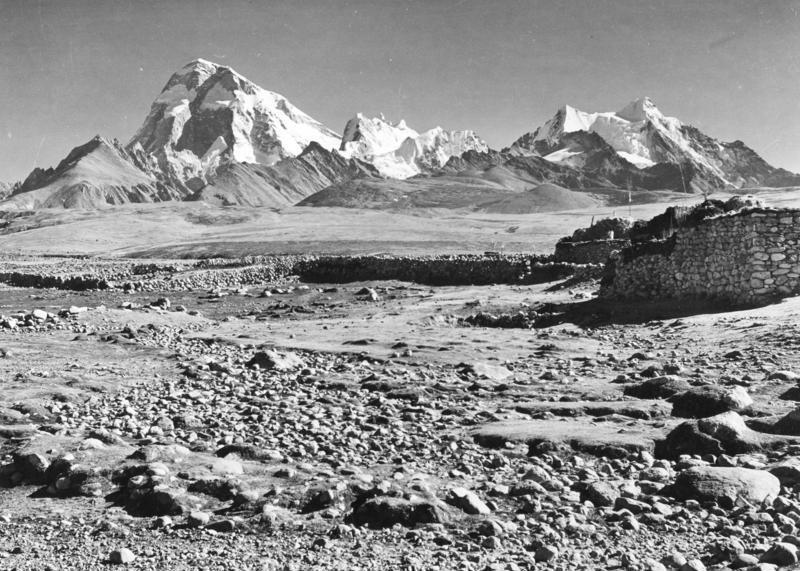
Jomolhari
卓木拉日峰 ཇོ་མོ་ལྷ་རི
Mountain · Xizang
Jomolhari or Chomolhari (Wylie: jo mo lha ri; sometimes known as "the bride of Kangchenjunga”, is a mountain in the Himalayas, straddling the border between Yadong County of Tibet, China and the Paro district of Bhutan. The north face rises over 2,700 metres above the barren plains.
Text: Wikipedia (CC BY-SA 4.0). Photo: Ernst Krause (CC BY-SA 3.0 de). Map

Tashichho Dzong
བཀྲ་ཤིས་ཆོས་རྫོང
Fort · Thimphu District
Tashichho Dzong is a Buddhist monastery and fortress on the northern edge of the city of Thimphu in Bhutan, on the western bank of the Wang Chu.
Text: Wikipedia (CC BY-SA 4.0). Photo: Christopher J. Fynn (CC BY 2.5). Map

Punakha Dzong
Religious · Punakha District
The Punakha Dzong, also known as Pungthang Dewa Chhenbi Phodrang, is the administrative centre of Punakha District in Punakha, Bhutan.
Text: Wikipedia (CC BY-SA 4.0). Photo: Jean-Marie Hullot (CC BY 3.0). Map

Jigme Dorji National Park
རྒྱལ་ཡོངས་སེམས་ཅན། ༼འབྲོང་གྱིམ་ཙི༽
Park & nature · Gasa District
Jigme Dorji National Park (JDNP), named after the late Jigme Dorji Wangchuck, is the second-largest National Park of Bhutan.
Text: Wikipedia (CC BY-SA 4.0). Photo: Andrewgrandison (CC BY-SA 3.0). Map

Rinpung Dzong
Religious · Paro District
Rinpung Dzong, sometimes referred to as Paro Dzong, is a large dzong - Buddhist monastery and fortress - of the Drukpa Lineage of the Kagyu school in Paro District, Bhutan. It houses the district Monastic Body as well as government administrative offices of Paro Dzongkhag.
Text: Wikipedia (CC BY-SA 4.0). Photo: Christopher Fynn (CC BY-SA 3.0). Map


Keep exploring
Also in Southern Asia: Afghanistan · Bangladesh · India · Iran · Maldives · Nepal · Pakistan · Sri Lanka
Last updated November 12, 2026. Sources: Wikipedia (CC BY-SA 4.0), Wikimedia Commons, OpenStreetMap (ODbL). Partner offers below are separate from this guide and never change what’s written here.
Plan & book Bhutan
Partner linksVoyaKin may earn a commission if you book through a partner link. It doesn’t change your price. How we work with partners
Flights
Kiwi.com
Search flights on Kiwi.com
Compare routes to and from this country.
Partner link. VoyaKin may earn a commission if you book through this link, at no extra cost to you.
Tours & experiences
 96 hBhutan Trip 5.0 (96)From US$1,143 on Viator
 96 hTrip to Bhutan 5.0 (51)From US$985 on Viator
 120 h5 Day Glimpse of Bhutan Thimphu Punakha and Paro 5.0 (37)From US$850 on Viator
 72 hMarvels of Bhutan-A Bespoke Travel Experience 5.0 (32)From US$895 on Viator
 168 hBhutan Spiritual & Wellness Tour Package With Monastic Stay 5.0 (32)From US$2,200 on Viator
 144 hBhutan Vacation (5 Nights-6 Days) 5.0 (31)From US$1,806 on Viator
 4 h–15 hExplore Bhutan with Local Guide 5.0 (28)From US$363 on Viator
 144 h6 Days Best of Bhutan | Thimphu, Punakha & Paro 5.0 (27)From US$980 on Viator
 240 h10 Days Essence of BHUTAN 5.0 (22)From US$3,295 on Viator
 240 h10 Days - Bhutan Mountain Biking tour 5.0 (19)From US$4,200 on Viator
Partner links via Viator. Ratings, reviews and prices come from Viator and may change. VoyaKin may earn a commission if you book through a partner link. It doesn’t change your price.
eSIM & staying connected
Saily
Stay connected: get an eSIM before you fly.
VoyaKin travelers get US$5 off their first Saily plan with code VOYAKIN9122.
VoyaKin readers’ code
Partner link. VoyaKin may earn a commission if you book through this link, at no extra cost to you.
Partner linksVoyaKin may earn a commission if you book through a partner link. It doesn’t change your price. How we work with partners