Travel Hub
Plan a trip to Afghanistan

Afghanistan at a glance
Afghanistan is a country in Southern Asia; its capital is Kabul. People mainly speak Persian and Pashto. The currency is the Afghan Afghani (AFN). VoyaKin maps 20 places to see here, including 2 UNESCO World Heritage sites.
- Flag
- 🇦🇫
- Capital
- Kabul
- Region
- Southern Asia
- Languages
- Persian, Pashto
- Currency
- Afghan Afghani (AFN)
- More
- Wikidata
Before you go: official information
Entry rules, visas and health requirements change. Confirm them with Afghanistan’s official immigration authority or its embassy before you book and again before you travel.
Check your own government’s travel advice before you go.
Places to see in Afghanistan
12 of the 20 places VoyaKin maps here. Descriptions from Wikipedia and photos from Wikimedia Commons, credited on each card.

Buddhas of BamiyanUNESCO
تندیسهای بودا در بامیان
Ruins · Bamyan Province
The Buddhas of Bamiyan were two monumental Buddhist reliefs in the Bamiyan Valley of what is now Afghanistan, carved possibly around the 6th-century.
Text: Wikipedia (CC BY-SA 4.0). Photo: James Gordon (CC BY 4.0). Map
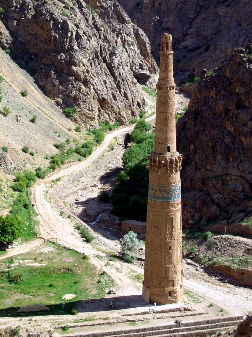
Minaret of JamUNESCO
د جام څلۍ
Ruins · Ghor Province
The Minaret of Jam is a UNESCO World Heritage Site in western Afghanistan. It is located in a remote and nearly inaccessible region of Shahrak District, Ghor Province, between the Jam and Hari Rivers.
Text: Wikipedia (CC BY-SA 4.0). Photo: david adamec (Public domain). Map

Kabul
کابل
City · Kabul Province
Kabul is the capital and largest city of Afghanistan. It is within the jurisdiction of Kabul District and has an estimated population of 5,333,284 people.
Text: Wikipedia (CC BY-SA 4.0). Photo: Sven Dirks, Wien (CC BY-SA 3.0). Map

Kandahar
کندهار
City · Kandahar Province
Kandahar is a major city in southern Afghanistan, serving as the capital of Kandahar Province. It is within the jurisdiction of Kandahar District and has an estimated population of 732,629 settled residents. Mullah Hekmatullah is the current mayor of the city.
Text: Wikipedia (CC BY-SA 4.0). Photo: Karla Marshall (Public domain). Map

Herat
هرات
City · Herat Province
Herat, also written as Harat or Hirat, and historically known as Haraiva, Horeiva and Hires, is a major city in western Afghanistan, serving as the capital of Herat Province and the Herat District.
Text: Wikipedia (CC BY-SA 4.0). Photo: Employee of the U.S. State Department (Public domain). Map

Mazar-i-Sharif
مزار شريف
City · Balkh Province
Mazar-i-Sharif or Mazar-e-Sharif is a city in northern Afghanistan, serving as the capital and largest city of Balkh Province. It has 12 city districts (nahias) and an estimated population of 568,013 people. Hafiz Abdul Rahman Himat is the current mayor of the city.
Text: Wikipedia (CC BY-SA 4.0). Photo: Peretz Partensky from San Francisco, USA (CC BY-SA 2.0). Map

Noshaq
نوشاخ
Mountain · Badakhshan Province
Noshaq is a 7,492 m (24,580 ft) high peak in the Hindu Kush lying on the border of Afghanistan and Pakistan. It is the highest mountain in Afghanistan, the second highest in the Hindu Kush after Terich Mir, and the 52nd highest in the world.
Text: Wikipedia (CC BY-SA 4.0). Photo: Louis Meunier (CC BY 3.0). Map

Mausoleum of Imam Ali
شین جومات
Religious · Balkh Province
The Mausoleum of Imam Ali, also known as the Blue Mosque, is a mausoleum and mosque complex located in Mazar-i-Sharif, the capital and largest city of Balkh Province in northern Afghanistan.
Text: Wikipedia (CC BY-SA 4.0). Photo: Saeedeh Joshaghani et al (CC BY-SA 4.0). Map


Band-e Amir National Park
پارک ملی بند امیر
Park & nature · Bamyan Province
Band-e Amir National Park is located in the central Bamyan Province of Afghanistan. It was established on 22 May 2009 as Afghanistan's first national park to promote and protect the natural beauty of a series of intensely blue lakes created by natural dams high in the Hindu Kush.
Text: Wikipedia (CC BY-SA 4.0). Photo: Carl Montgomery (CC BY 2.0). Map

Gardens of Babur
Bagh-e Babur
Park & nature · Kabul Province
The Gardens of Babur, is a historic site in District 5 of Kabul, Afghanistan. It is located in the Guzargah neighborhood, with the Sher Darwaza mountain being to the east, Chihil Sutun to the south, and the Kabul Zoo to the northwest.
Text: Wikipedia (CC BY-SA 4.0). Photo: Jim Kelly (CC BY 2.0). Map

Arg
ارګ
Fort · Kabul Province
The Arg is the presidential palace of Afghanistan, located in Kabul. Since the 2021 abolition of the Afghan presidency by the Taliban, it has served as the meeting place of the Cabinet of Afghanistan.
Text: Wikipedia (CC BY-SA 4.0). Photo: U.S. Secretary of Defense (Public domain). Map


Keep exploring
Also in Southern Asia: Bangladesh · Bhutan · India · Iran · Maldives · Nepal · Pakistan · Sri Lanka
Last updated November 12, 2026. Sources: Wikipedia (CC BY-SA 4.0), Wikimedia Commons, OpenStreetMap (ODbL). Partner offers below are separate from this guide and never change what’s written here.
Plan & book Afghanistan
Partner linksVoyaKin may earn a commission if you book through a partner link. It doesn’t change your price. How we work with partners
Flights
Kiwi.com
Search flights on Kiwi.com
Compare routes to and from this country.
Partner link. VoyaKin may earn a commission if you book through this link, at no extra cost to you.
eSIM & staying connected
Saily
Stay connected: get an eSIM before you fly.
VoyaKin travelers get US$5 off their first Saily plan with code VOYAKIN9122.
VoyaKin readers’ code
Partner link. VoyaKin may earn a commission if you book through this link, at no extra cost to you.
Partner linksVoyaKin may earn a commission if you book through a partner link. It doesn’t change your price. How we work with partners