Travel Hub
Plan a trip to Faroe Islands

Faroe Islands at a glance
Faroe Islands is a territory in Northern Europe; its capital is Tórshavn. People mainly speak Faroese. The currency is the Danish Krone (DKK). VoyaKin maps 20 places to see here.
- Flag
- 🇫🇴
- Capital
- Tórshavn
- Region
- Northern Europe
- Languages
- Faroese
- Currency
- Danish Krone (DKK)
- More
- Wikidata
Before you go: official information
Entry rules, visas and health requirements change. Confirm them with Faroe Islands’s official immigration authority or its embassy before you book and again before you travel.
Check your own government’s travel advice before you go.
Places to see in Faroe Islands
12 of the 20 places VoyaKin maps here. Descriptions from Wikipedia and photos from Wikimedia Commons, credited on each card.

Tórshavn
Town
Tórshavn, locally referred to as Havn, is the capital and largest city of the Faroe Islands. It is located in the southern part on the east coast of Streymoy.
Text: Wikipedia (CC BY-SA 4.0). Photo: Stig Nygaard from Copenhagen, Denmark (CC BY 2.0). Map


Vágar
Island
Vágar is one of the 18 islands in the archipelago of the Faroe Islands and the most westerly of the large islands. With a size of 178 square kilometres, it ranks third in size, behind Streymoy and Eysturoy. Vágar region also comprises the island of Mykines.
Text: Wikipedia (CC BY-SA 4.0). Photo: Erik Christensen (CC BY-SA 3.0). Map
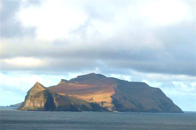
Mykines
Island
Mykines is the westernmost of the 18 main islands of the Faroese Archipelago.
Text: Wikipedia (CC BY-SA 4.0). Photo: Erik Christensen (CC BY-SA 3.0). Map

Streymoy
Island
Streymoy is the largest and most populated island of the Faroe Islands. The capital, Tórshavn, is located on its southeast coast. The name means "island of currents". It also refers to the largest region of the country that also includes the islands of Hestur, Koltur and Nólsoy.
Text: Wikipedia (CC BY-SA 4.0). Photo: Erik Christensen (CC BY-SA 3.0). Map

Eysturoy
Island
Eysturoy is a region and the second-largest of the Faroe Islands, both in size and population.
Text: Wikipedia (CC BY-SA 4.0). Photo: Renno Hokwerda (CC BY-SA 4.0). Map


Slættaratindur
Mountain
Slættaratindur is the highest mountain in the Faroe Islands, at an elevation of 880 metres. It is located in the northern part of Eysturoy, between the villages of Eiði, Gjógv, and Funningur. Funningur is situated at the base of the mountain.
Text: Wikipedia (CC BY-SA 4.0). Photo: Erik Christensen, Porkeri (Contact at the Danish Wikipedia) (CC BY-SA 3.0). Map

Fuglafjørður
Town
Fuglafjørður is a village on Eysturoy's east coast in the Faroe Islands. Its name means "fjord of birds".
Text: Wikipedia (CC BY-SA 4.0). Photo: Erik Christensen (CC BY-SA 3.0). Map

Tvøroyri
Town · Suðuroy region
Tvøroyri is a village on the north side of the Trongisvágsfjørður on the east coast of Suðuroy island in the Faroe Islands. Together with Froðba, Trongisvágur, Líðin and Øravík it forms Tvøroyri Municipality.
Text: Wikipedia (CC BY-SA 4.0). Photo: kallerna (CC BY-SA 4.0). Map

Tórshavn Cathedral
Havnar Kirkja
Religious
Tórshavn Cathedral is the second oldest received church of the Faroe Islands, on Tinganes in the old town of Tórshavn. Painted white, and roofed with slate, it was established in 1788. The cathedral lies in the north of the peninsula of Tinganes and is one of the main attractions of the town.
Text: Wikipedia (CC BY-SA 4.0). Photo: Erik Christensen (CC BY-SA 3.0). Map

Cape Enniberg
Mountain
Cape Enniberg is a cliff located on the Island of Viðoy. At 754 metres (2,474 ft) high, it is one of the highest promontories in the world.
Text: Wikipedia (CC BY-SA 4.0). Photo: Thorbjoern (CC BY-SA 3.0). Map


Keep exploring
Also in Northern Europe: United Kingdom · Åland Islands · Denmark · Estonia · Finland · Guernsey · Iceland · Ireland
Last updated November 12, 2026. Sources: Wikipedia (CC BY-SA 4.0), Wikimedia Commons, OpenStreetMap (ODbL). Partner offers below are separate from this guide and never change what’s written here.
Plan & book Faroe Islands
Partner linksVoyaKin may earn a commission if you book through a partner link. It doesn’t change your price. How we work with partners
Flights
Kiwi.com
Search flights on Kiwi.com
Compare routes to and from this country.
Partner link. VoyaKin may earn a commission if you book through this link, at no extra cost to you.
Tours & experiences
 1.5 hExclusive 1,5 Hour Drangarnir Boat Tour 4.9 (41)From US$152 on Viator
 1.5 hPuffin Safari Boat Tour 4.8 (36)From US$152 on Viator
 1 hDrangarnir Sea Stacks Boat Tour 4.7 (31)From US$99 on Viator
- 1 hGuided Puffin Safari Boat Tour 4.6 (24)From US$99 on Viator
 1.5 hPrivate and Guided Walking Tórshavn City Tour 5.0 (7)From US$114 on Viator
 1 hBoat tour to Drangarnir Sea Stacks 5.0 (5)From US$99 on Viator
 8 hPrivate Kallur Lighthouse Hike 5.0 (2)From US$687 on Viator
 2.5 hConcerto Grotto - Sea Cave Concert 5.0 (1)From US$304 on Viator
 1.3 h–1.8 hGhosts of Tórshavn: Self-Guided Haunted Mystery Walk 4.9 (8)From US$6 on Viator
 1.5 hPrivate Sightseeing Tour with Local Skipper to Vágar Area 4.8 (6)From US$915 on Viator
Partner links via Viator. Ratings, reviews and prices come from Viator and may change. VoyaKin may earn a commission if you book through a partner link. It doesn’t change your price.
eSIM & staying connected
Saily
Stay connected: get an eSIM before you fly.
VoyaKin travelers get US$5 off their first Saily plan with code VOYAKIN9122.
VoyaKin readers’ code
Partner link. VoyaKin may earn a commission if you book through this link, at no extra cost to you.
Partner linksVoyaKin may earn a commission if you book through a partner link. It doesn’t change your price. How we work with partners