Travel Hub
Plan a trip to Falkland Islands
Falkland Islands at a glance
Falkland Islands is a territory in South America; its capital is Stanley. People mainly speak English. The currency is the Falkland Islands Pound (FKP). VoyaKin maps 20 places to see here.
- Flag
- 🇫🇰
- Capital
- Stanley
- Region
- South America
- Languages
- English
- Currency
- Falkland Islands Pound (FKP)
- More
- Wikidata
Before you go: official information
Entry rules, visas and health requirements change. Confirm them with Falkland Islands’s official immigration authority or its embassy before you book and again before you travel.
Check your own government’s travel advice before you go.
Places to see in Falkland Islands
12 of the 20 places VoyaKin maps here. Descriptions from Wikipedia and photos from Wikimedia Commons, credited on each card.

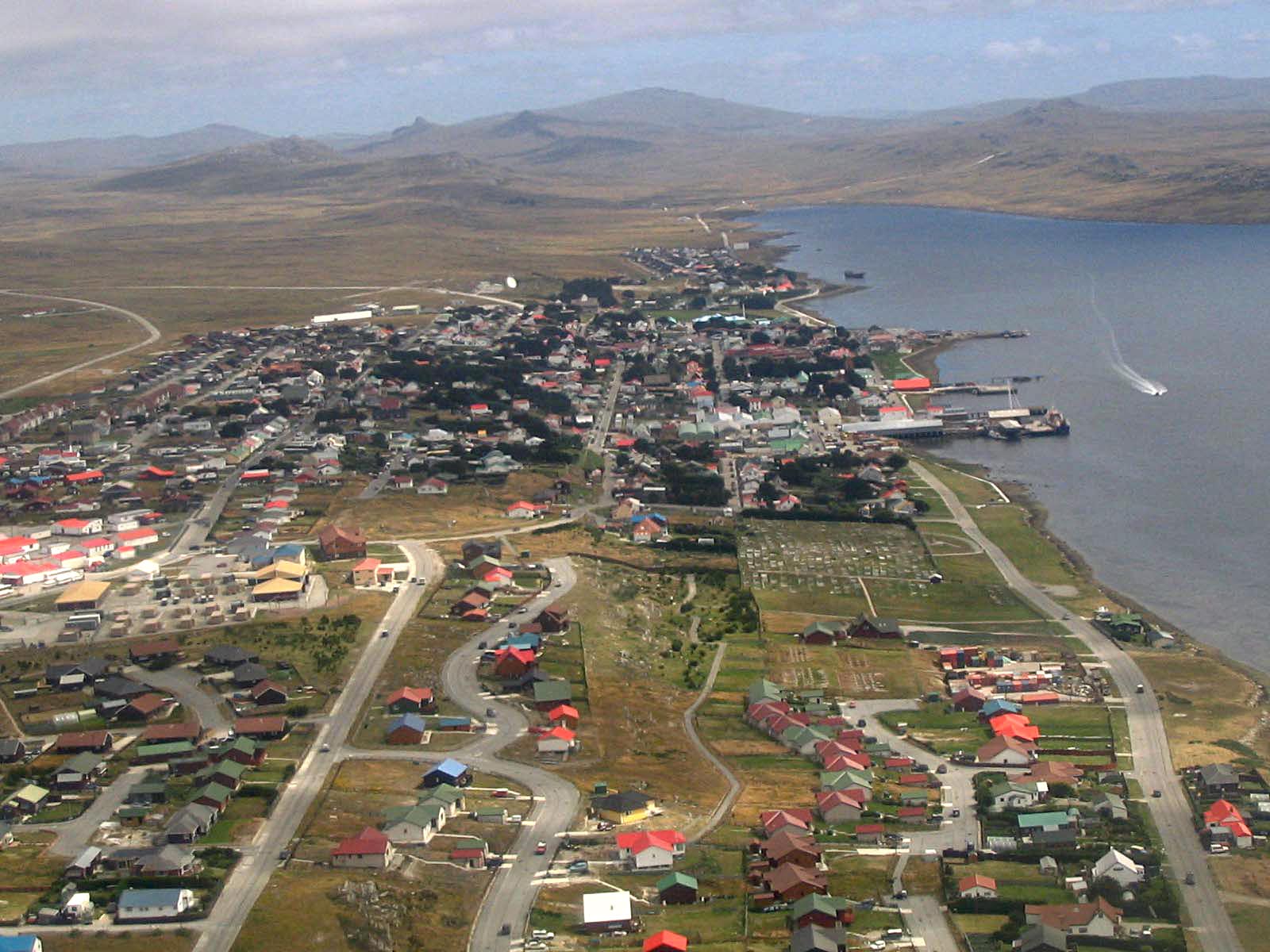
Stanley
City
Stanley is the capital city of the Falkland Islands. It is located on the island of East Falkland, on a north-facing slope in one of the wettest parts of the islands.
Text: Wikipedia (CC BY-SA 4.0). Photo: Wikimedia Commons: Aerial photo Port Stanley.jpg (CC BY-SA 3.0). Map

East Falkland
Island
East Falkland is the largest island of the Falklands in the South Atlantic, having an area of 6,605 km2 or 54% of the total area of the Falklands.
Text: Wikipedia (CC BY-SA 4.0). Photo: Travellers & Tinkers (CC BY-SA 3.0). Map

West Falkland
Island
West Falkland the second largest of the Falkland Islands in the South Atlantic. It is a hilly island, separated from East Falkland by the Falkland Sound. Its area is 4,532 square kilometres, 37% of the total area of the islands. Its coastline is 1,258.7 kilometres long.
Text: Wikipedia (CC BY-SA 4.0). Photo: Ben Tubby (CC BY 2.0). Map

Mount Usborne
Mountain
Mount Usborne is a mountain on East Falkland. At 705 m (2,312 ft) above sea level, it is the highest point in the Falkland Islands. It is 5 metres (16 ft) taller than Mount Adam, the highest peak on West Falkland.
Text: Wikipedia (CC BY-SA 4.0). Photo: chris lovelock (CC BY 2.0). Map

Saunders Island
Island
Saunders Island is the fourth largest of the Falkland Islands, lying north west of West Falkland. The island is run as a sheep farm.
Text: Wikipedia (CC BY-SA 4.0). Photo: Wikimedia Commons: 2884-saunders-landscape RJ.jpg (CC BY-SA 4.0). Map

Weddell Island
Island
Weddell Island is one of the Falkland Islands in the South Atlantic, lying off the southwest extremity of West Falkland.
Text: Wikipedia (CC BY-SA 4.0). Photo: Wikimedia Commons: Weddell Island 2 - Falkland Islands.jpg (Public domain). Map

Port Egmont
Ruins
Port Egmont was the first British settlement in the Falkland Islands, on Saunders Island off West Falkland, and is named after John Perceval, 2nd Earl of Egmont, who was First Lord of the Admiralty at the time of its founding.
Text: Wikipedia (CC BY-SA 4.0). Photo: CIA (Public domain). Map

Christ Church Cathedral
Religious
Christ Church Cathedral, in Stanley, Falkland Islands, is the southernmost Anglican cathedral in the world. It is the parish church of the Falkland Islands, South Georgia and the British Antarctic Territories. The Parish of the Falkland Islands is part of the Anglican Communion.
Text: Wikipedia (CC BY-SA 4.0). Photo: Travellers & Tinkers (CC BY-SA 3.0). Map

San Carlos Water
Beach
San Carlos Water is a bay/fjord on the west coast of East Falkland, facing onto the Falkland Sound.
Text: Wikipedia (CC BY-SA 4.0). Photo: Chris Pearson from Leuchars, Scotland (CC BY 2.0). Map


Lady Elizabeth
Landmark
Lady Elizabeth is a wrecked iron barque of 1,155 tons built by Robert Thompson Jr. of Southwick, Sunderland and launched on 4 June 1879. Robert Thompson Jr. was one of the sons of Robert Thompson Sr. who owned and operated the family ran shipyard J. L. Thompson & Sons.
Text: Wikipedia (CC BY-SA 4.0). Photo: Wikimedia Commons: Lady Elizabeth.jpg (Public domain). Map


Keep exploring
Also in South America: Brazil · Colombia · Argentina · Bolivia · Bouvet Island · Chile · Ecuador · French Guiana
Last updated November 12, 2026. Sources: Wikipedia (CC BY-SA 4.0), Wikimedia Commons, OpenStreetMap (ODbL). Partner offers below are separate from this guide and never change what’s written here.
Plan & book Falkland Islands
Partner linksVoyaKin may earn a commission if you book through a partner link. It doesn’t change your price. How we work with partners
Flights
Kiwi.com
Search flights on Kiwi.com
Compare routes to and from this country.
Partner link. VoyaKin may earn a commission if you book through this link, at no extra cost to you.
Tours & experiences
 4 h–5 hPrivate Falkland Island Tour Gypsy Cove Cape Pembroke and Stanley 5.0 (12)From US$372 on Viator
 6.5 hKelp Point - Private 4x4 Tour - Elephant Seals and Penguins 5.0 (10)From US$437 on Viator
 4 h–5 hLet the Bertha’s Beach Penguins Make You Smile 5.0 (20)From US$372 on Viator
 4 h–5 hBertha’s Beach & Beyond - Your Falklands, Your Way! 4.9 (80)From US$403 on Viator
 6.3 hVolunteer Point in Falkland Islands 4.8 (223)From US$398 on Viator
 5 h–6 hPrivate Falkland Island Wildlife Tour in Bertha Beach and Stanley 4.8 (15)From US$406 on Viator
 1 hGentoo Penguin Colony Falklands Tour with Transportation 4.8 (27)From US$40 on Viator
 5 hPrivate Penguin Paradise Tour: Penguins, Scenery & Stanley 4.8 (42)From US$555 on Viator
 5 h–6 hPrivate Falklands Guided Eco Nature Tour 5.0 (9)From US$348 on Viator
 5 hPrivate Coastal Gems Tour: Penguins, Scenery & Stanley 5.0 (8)From US$528 on Viator
Partner links via Viator. Ratings, reviews and prices come from Viator and may change. VoyaKin may earn a commission if you book through a partner link. It doesn’t change your price.
eSIM & staying connected
Saily
Stay connected: get an eSIM before you fly.
VoyaKin travelers get US$5 off their first Saily plan with code VOYAKIN9122.
VoyaKin readers’ code
Partner link. VoyaKin may earn a commission if you book through this link, at no extra cost to you.
Partner linksVoyaKin may earn a commission if you book through a partner link. It doesn’t change your price. How we work with partners